
Country France Canton Pont-de-Roide Time zone CET (UTC+1) Local time Thursday 9:52 PM | Department Doubs Population (2012) 4,309 Area 13.58 km² Arrondissement Montbéliard | |
 | ||
Region Bourgogne-Franche-Comté Weather 10°C, Wind S at 3 km/h, 87% Humidity | ||
Pont-de-Roide (also Pont-de-Roide-Vermondans) is a commune in the Doubs département in the Bourgogne-Franche-Comté region in eastern France.
Contents
Map of 25150 Pont-de-Roide, France
Geography
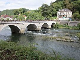
The city is at the heart of the Pays de Lomont, 17 km (11 mi) from Montbéliard at the confluence of the Doubs River, the Ranceuse, and the Roide; it is therefore located at the crossroad of different valleys. On the east end of the town are high cliffs known as les Roches, leading to a plateau near the Franco-Swiss border.
History
In 1973, the adjacent village of Vermondans joined the commune of Pont-de-Roide. In 2013 the fusion was made official by the creation of a new commune: Pont-de-Roide - Vermondans.
References
Pont-de-Roide Wikipedia(Text) CC BY-SA