
River system Elbe Length 31.3 km Country Germany | Basin size 104 km² Basin area 104 km² | |
 | ||
Main source in Saxony
ca. 380 m above sea level (NN) River mouth confluence with the Sebnitz at Lachsbach near Porschdorf
ca. 150 m above sea level (NN) Landmarks Cities: keine
Large towns: keine
Small towns: Neustadt in Sachsen, Hohnstein | ||
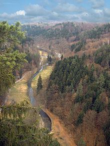
The Polenz is the right-hand, smaller headstream of the Lachsbach in the German state of Saxony. Its lower course flows through the western Elbe Sandstone Mountains in a canyon-like valley.
Contents
Map of Polenz, Germany
Geography
The Polenz rises from nine springs on the German-Czech border between the villages of Langburkersdorf and Nová Víska (Neudörfel). The springs are located southwest of the 461 m high Roubený (Raupenberg) mainly on German territory and unite at a height of 363 m above sea level. The upper reaches of the Polenz form the natural boundary between the Hohwald and Saxon Switzerland.
Tributaries
The most important tributaries of the Polenz are the:
References
Polenz Wikipedia(Text) CC BY-SA