
Country Czech Republic Time zone UTC+1 Elevation 458 m Local time Thursday 12:39 AM | District (okres) Klatovy Postal Code (PSČ) 339 01 Area 17.65 km² | |
 | ||
Region (kraj) Plzeňský kraj (Pilsener) Weather 4°C, Wind E at 16 km/h, 95% Humidity | ||
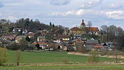
The Poleň village is situated in the southwestern part of Czech Republic in the middle of Europe. On the date 2008-12-31 there were 295 inhabitants (in all of its parts). There are seven parts of the Municipality of Poleň: villages Poleň, Mlýnec, Poleňka, Pušperk and Zdeslav and the settlements Čekanice and Liška.
Contents
Map of 339 01 Pole%C5%88, Czechia
Geography
This place lies in 458 metres above sea level in the valley of the Poleňka Stream. From the eastern and southern side bordered with the Bítovy mountains with the peaks Doubrava (727 m), Malý Bítov (668 m) and Velký Bítov (713 m).
The nearest neighbours of Poleň are Pušperk, Poleňka and Slatina on North, Drslavice on East, Mlýnec and Zdeslav on Southwest and Černíkov on West.
History
The first written reference about the village comes from 1245. . In the sheet which illustrates the disposal of Újezd Přeštický to Monastery of Kladruby by Queen Kunhuta, Blažej ze Švihova, the son of Budivoj of Švihov as an approver has been mentioned. Afterwards when the Pušperk Castle (originally known as Fuchsberg) had been built close to Poleň, the village was sharing the destiny of this castle for centuries.