
Elevation 91 m Population 16,794 (2014) | Time zone CET (UTC+1) Area 34.16 km² Local time Wednesday 7:43 PM | |
 | ||
Parroquia Combarro, Raxó, San Xoán de Poio, San Salvador de Poio, Samieira Weather 7°C, Wind NW at 6 km/h, 81% Humidity | ||
Poio is a municipality in Galicia, Spain in the province of Pontevedra. Poio is located in the North shore of the Ría de Pontevedra, between Sanxenxo and the provincial capital, Pontevedra. The municipality is adjacent with Meaño, Meis, Pontevedra and Sanxenxo and offers a rich fusion of mountain and sea areas.
Contents
Map of Poio, Pontevedra, Spain
Tambo island, an uninhabited island located in the middle of the Pontevedra estuary, officially belongs to Poio but it is under the control of the Spanish Navy and the disembarkment is not allowed.
Geography
Poio has an approximate area of 34 square kilometers. Its highest peak is Mount Castrove, which 667 meters high and from where one can see views of the Pontevedra and Arosa estuaries. The views also spotlight the Alto de Raxó and Samieira. Its more than 20 coastal km are full of beautiful beaches with quiet waters.
Tambo island has 0,28 square kilometers and its highest peak is 80 meters high.
Demography
Poio is a dormitory area of the city of Pontevedra. It has a growing market due to its proximity to the urban center (only the Lérez river separates the two municipalities). The parish of San Salvador, the nearest to the city, is the parish that increases the census. The tourism industry has begun to thrive in Raxó and Combarro within the last few years.
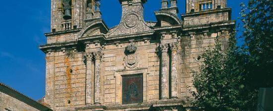
Sights
Sights include the Monastery of San Xoán de Poio, the picturesque fishing village of Combarro with its Hórreos by the sea and several prehistoric rock engraving sites; all declared Bien de Interés Cultural (Heritage of Cultural Interest).