
- left Elk Fork - elevation 663 ft (202 m) | - elevation 987 ft (301 m) Basin area 156.7 km² | |
 | ||
- location | ||
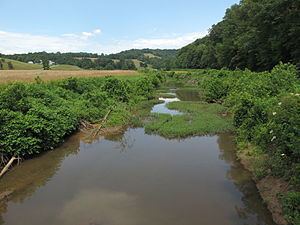
Point Pleasant Creek is a tributary of Middle Island Creek, 10.4 miles (16.7 km) long, in northwestern West Virginia in the United States. Via Middle Island Creek and the Ohio River, it is part of the watershed of the Mississippi River, draining an area of 60.5 square miles (157 km2) in a rural region on the unglaciated portion of the Allegheny Plateau.
Map of Point Pleasant Creek, West Virginia, USA
Point Pleasant Creek rises in southwestern Wetzel County, approximately 2 miles (3.2 km) south of New Martinsville, and flows southward into Tyler County and through the unincorporated community of Kidwell, near which it collects its largest tributary, the Elk Fork. It flows into Middle Island Creek on the northern boundary of the town of Middlebourne. Upstream of Kidwell, it is paralleled by West Virginia Route 180; for the remainder of its course it is mostly paralleled by West Virginia Route 18.