
Topo map USGS Heath Prominence 70 m | Elevation 571 m | |
 | ||
Parent ranges Appalachian Mountains, Green Mountains | ||
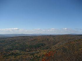
Pocumtuck Mountain, a mountain peak west of the abandoned Catamount settlement, is technically located in Charlemont, Massachusetts. Its summit ledge features wide views of western Franklin County and northern Berkshire County. Pocumtuck Mountain is often confused with the nearby Pocumtuck Range in Deerfield, Massachusetts.
Map of Pocumtuck Mountain, Charlemont, MA 01370, USA
The mountain was named after the Pocumtuc Indians on October 16, 1855 during one of Catamount's Old Homes Days Festival. Such festivals were held often on the scenic mountain - including one visited by Massachusetts Governor John Davis Long.
Except for areas belonging to Catamount State forest, the ledges and surrounding land are privately owned. Trespassing for any reason is not permitted.
References
Pocumtuck Mountain Wikipedia(Text) CC BY-SA