
First ascent 1875 Mountain range Bernina Range | Elevation 3,363 m Prominence 432 m | |
 | ||
Similar Piz Tremoggia, Piz Glüschaint, Il Chapütschin, Monte del Forno, Piz Bernina | ||
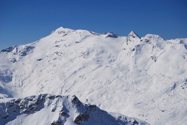
Piz Fora is a mountain of the Bernina Range (Alps), located on the border between Italy and Switzerland. Its summit has an elevation of 3,363 metres (11,033 ft) and is the tripoint between the valleys of Val Fedoz and Val Fex (both in Graubünden) and Val Malenco (in Lombardy).
Contents
Map of Piz Fora, 7514 Sils im Engadin%2FSegl, Switzerland
Introdution
The Sassa di Fora, Piz Fora on CNS, is a massive and complex mountain located on the main watershed of the Alpine chain, between the Valmalenco and the Alta Engadina and is also the last great elevation to the west of the Bernina Group. On the summit converge three distinct ridges, slightly inclined, which delimit as many sides; NW that is the head of Val Fedoz and is shrouded by the beautiful Vadrec da Fedoz, which gives the mountain the structure of a four, with the great glacial plateau, below the summit, cabinet above a rocky rib. That NE, also covered with ice, the steepest complex than Western, but less impressive, hosts the contiguous Vadret dal Güz and Vadret da Fex and forms the western summit of the Val Fex. Much more complex than the south side, the Gold Pass to W, the Fuorcla from Chapütsch to E, measuring more than three km long and in some places the wall is more than 600 meters high. One of the most extensive and impressive rocky structures of the entire Bernina Group. Under the steep slopes of the Fora nozzle is the only glacial apparatus of the southern slope, the small glacier Sassa Fora. The excursion that takes us to the summit of this beautiful mountain, starts from Chiareggio in Valmalenco, but can also be done from Sils-Maria in the Engadine, the difficulties and the travel times are the same. The S path has the advantage of being much more scenic and opened, N you can save three hundred meters in altitude, but the development is greater. In both cases there is no foothold and climb is long and tiring, reserved for well-trained hikers and experienced progression on steep ice slopes. The view from the top is great, just look at the picture of scaled images.
Access: From Sondrio (west of town) follow the road to Valmalenco. Once in church in Valmalenco continue for Chiareggio, where you park.
Report of the climb: Top n ° 1846, Rising slope: SW-W-SW, Difference of ascent: 1800 m - Total: 3600 m, Rise Time: 6.30 h - Total: 11.30 h, Recommended season: Summer
Description of the climb: For W Chiareggio country begins the road that leads to the Passo del Muretto, in part by using the path that shortens the path, partly following the road, you come to a junction, where you leave it and follow the detour to the Golden Alpe (q. 2010 m). Reached the beautiful alpine pasture, in a panoramic position on the N of the Accident and Monte del Forno, briefly follows E to the path that leads to Val Nevasco, for about a hundred meters, in order to avoid the rocky prominence and the steep slopes above the alp. Leaving the path up towards N, in a sparse larch forest, to arrive at about (q. 2400 m) to a plateau pastureland, to E of the grassy spur of Dosso Calvo. After reaching the highest part of the plateau, we follow it to the left a clear and steep grassy rib which leads along the ridge of the hill above. The path becomes more evident now, the grassy ridge need to go back and then detritus until you reach the base of the cliff, to SSE of the Gold Pass. From here it turns to the left (W) and you enter in fact into the wall; initially go up an easy channel of broken rocks, for a little over a hundred meters, you then gradually moves to the left, on rocky soil and debris, with logical path and always easy (I °), in the direction of the now evident Golden step (q. 3083 m), from Furcela Fedoz on the CNS. So far the difficulty is (F). From the pass, properly equipped, it easily falls on the glacier (though attention to the numerous crevasses) and slightly downhill, losing a few tens of meters in altitude, cross towards the north, in the direction of the steep icy slope that connects the bottom of the hanging glacier with the plateau hanging below the summit. The ice slope the climb slightly to the right, not without difficulty if it were living present ice. Then it follows a serac area, among which must extricate on slender bridges of ice and partition walls. Then continue in the direction of the mountain NNW ridge on easier but always crevassed glacier. He reached the plateau turns towards SSE and gently sloping traverse long, in the direction of the steep icy chute that allows you to access the SW ridge. The bergschrund can create serious problems, in our case it has been exceeded to the right of a providential bridge. The icy slope to climb, up about fifty meters, is very steep, about 50/55 ° and you need to make with ice screws. Reached the top edge of the slide ending the difficulties and follow the broad SW ridge, leaning slightly to the right, to the summit.
Descent: From the top edge of the ice chute they offer three ways of reaching the plateau below:
1) go down the chute abseiling;
2) continue along the easy SW crest and after passing the first projection rock, you go down a shorter icy slope than the rising;
3) you can follow fully the SW ridge to the Gold Pass (normal route), A guide of the CAI / TCI Monti of Italy: Bernina, considering the difficulty (F). In any case, continue the descent along the ascent itinerary.