Pitigliano and its area were inhabited in Etruscan times but the first extant written mention of it dates only to 1061. In the early 13th century it belonged to the Aldobrandeschi family and by the middle of the century it had become the capital of the surrounding county.
In 1293 the county passed to the Orsini family, signalling the start of 150 years of on-again/off-again wars with Siena, at the end of which, in 1455, a compromise of sorts was reached: Siena acknowledged the status of county to Pitigliano, which in exchange placed herself under the sovereignty of Siena.
From then onwards the history of Pitigliano resorbs into the gradually wider ambit first of the Grand Duchy of Tuscany (1562) then of the united Kingdom of Italy.
Etruscan remains
Pitigliano is home to a series of artificial cuts into the tufa rock to varying depths ranging from less than 1 metre (3.3 ft) to over 10 metres (33 ft). At the bottom of these cuts (Italian: tagliate) are carved channels, apparently for water, although some take the form of steps. The purpose of the cuts is not known: the three main theories are that they were roads, quarries, or water conveyance schemes; they radiate outward from the base of the butte of Pitigliano, down to the rivers then back to the top of the plateau that surrounds the town. A few very brief Etruscan inscriptions are said to have been found on the walls of the cuts, but are ill documented.
Medieval and Renaissance monuments
The former Cathedral of Santi Pietro e Paolo.The church of Santa Maria.The Orsini Fortress, which achieved its present state in 1545 but represents a reworking of the earlier medieval fortressthe town's walls and gates, the best preserved of which is the Porta Sovana.remains of a tall and very visible aqueduct at the very top of the butte.Synagogue and Jewish community
For several hundred years Pitigliano was a frontier town between the Grand Duchy of Tuscany and, to the south, the Papal States. For this reason, the town was home to a flourishing and long-lived Jewish community, mostly made up by people fleeing from Rome during the Counterreformation persecutions. Jews of the town used one of the caves for their ritual Passover matzoh bakery, the "forno delle azzime" described in detail in Edda Servi Machlin's "Classic Cuisine of the Italian Jews." [1] After the promulgation of racial laws under Nazi influence, all the Jews of the town reportedly escaped capture with the help of their Christian neighbors.[2] Although there are almost no Jews left in town, not enough to provide a minyan, the synagogue (1598, with furnishings of the 17th and 18th centuries) is still officiated from time to time. It was restored in 1995.
The Tempietto ("Small temple") is a small cave, probably of natural origin but considerably reworked by human hands, lying a few hundred meters outside the central district, yet far above the Lente valley. Its purpose and builders remain unknown. Locally it is referred to as a "paleochristian tempietto", but this has never been confirmed; it must date to Late Antiquity or the early Middle Ages, although it may replace an Etruscan or Roman arcosolium[3].
The municipal area of Pitigliano lies in the western part of 'Area del Tufo. It is bordered to the north by the town of Sorano, south-east with the municipalities of Latium Farnese, Ischia di Castro, Latera and Valentano from which is bordered from the north end of the Lamone, west with the town of Manciano.
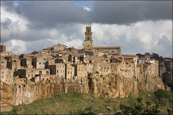
Arriving from the [sea[coast]] in Pitigliano, from the renown Maremma climbing the Highway 74, visitors can see the features houses that protrude from a large outcrop of tuff, very sheer. The cliff of Pitigliano is surrounded on three sides by many ravines, full of caves dug into the tuff in the valley flow the rivers Lente, Meleta and Prochio.
The municipal share rises to hills that vary between 300 and 663 metres (984 and 2,175 ft) above sea level of Poggio Evangelista, which marks the border with Lazio at the east end, and the area of the Paduletto Pantanello has undergone rehabilitation in the Lorraine period.
Hardness: Zone 3 (low seismicity), PCM Ordinance 3274 of 20/03/2003The municipality area of Pitigliano, while presenting different local situations on the basis of 'topography is characterized by rather low winter temperatures, which can occur during prolonged periods, despite the daily maximum values are often pleasing. On the contrary, in summer the heat can be very intense, though usually accompanied by low Relative humidity.
Consequently, the town has been classified in zone E with a sum of 2195 degree days, allowing the power of heating between October 15 and April 15, up to a maximum of 14 hours per day.
According to data available for the 30-year average 1951–80 for the only weather station located within the municipal area and in the table below, the average annual temperature is about 14.1 °C (57.4 °F) at 313 metres (1,027 ft) above sea level in Pitigliano, while the average annual rainfall is 926 millimetres (36.5 in).
Climate classification: E Zone, 2195 GGAtmospheric diffusion: high, Ibimet CNR 2002SynagogueThe historic center is characterized mainly by the 16th-century synagogue, in which the Aron stand on the back wall and the center Tevah; preserved inscriptions on the walls are Bible verses while overhead the women's gallery is reserved for women. Under the Jewish temple are the venues for the ritual bath, the striking of unleavened oven, the kosher butcher, the kosher winery and Dyeing. The ancient Ghetto revolved around the synagogue along the present path Zuccarelli and in some lanes that originate from this road onto the alley Goito you reach the Old Mill Pelliccetti who was serving the Jewish community.
Church of Santa Maria and San RoccoBuilt in medieval times on an old pagan temple and restored in the late-Renaissance forms, occurs in an unusual classroom trapezoid divided into three aisles which are preserved some traces of frescoes.
Pitigliano CathedralThe Cathedral of Saints Peter and Paul was built prior to 1500, and remodeled during the 16th century and later in a baroque-style. The façade is flanked on the left from the bell tower that has plastered the bottom, but maintains its original medieval appearance in tufa. The baroque interior houses works by Guidoccio Cozzarelli and Pietro Aldi. The cathedral overlooks the Piazza San Gregorio, which is home to the Palace of the Community and the Palace of Justice.
Oratory of the Holy CrossSmall 17th century religious building located not far from the Cathedral Square in Gregory VII, which can be accessed from the loggia of the Palazzo della Fiscaleria towards Via Manin.
Church of St. AnthonyReligious building built during the 13th century on Via Zuccarelli, was transformed and used as a civilian after his final abandonment and subsequent desecration. On the front there are elements that testify to the religious past.
Church of San RoccoBuilt during the Renaissance and the alley between Via Vignoli of San Rocco, was also transformed as a result of its abandonment and subsequent desecration. The facade has remained a niche containing a statue.
Oratory RockAt the gate of Sovana are found stretches of Etruscan walls and numerous caves dug into the tuff, once Etruscan tombs that were later transformed into the current wineries, among them is to remember the quaint Oratory Rock, small cave used as a place of worship dating back the 4th century that opens in a rock along the road to Sovana.
Church of Santa Maria Assunta19th-century church built outside the walls, in Piazza Dante Alighieri, in the eastern suburb that was developing at that time. Romanesque Revival style, is remarkable for its bell tower, which rises near.
Church of San MicheleBuilt in medieval times along the road outside the walls of the same name, the religious building was expanded during the 18th century with the construction of the rectangular Nave. After being abandoned, has been modified, transformed and used for civil purposes.
Church of Our Lady of the FlowersBuilt as a chapel during the Renaissance, is along the same name on the outside walls. In later centuries, the religious building was enlarged, while retaining the original design elements discretely from the 16th century.
Jewish cemeteryBeyond the stream Meleta that borders the village to the south, is worth visiting the Jewish cemetery, built in the second half of the 16th century when the Orsini conceded that land to their family doctor for a Jewish burial of his wife. Near the Jewish cemetery lies the open-air museum
Alberto Manzi.
Chapel of the Holy Apostles James and PhilipEncircled just outside the town along the Vie Cave Gradone the south of the historic center, is a small rural chapel recently restored, which has retained the stylistic elements typical of the period of construction.
Sanctuary of Our Lady of GracePitigliano is situated on a cliff of tuff, its spectacular scenic view, coming from Manciano, Grosseto, the hairpin before the Shrine of Our Lady of Grace. This religious building, built in the late medieval period as a rural chapel was transformed into a shrine to the Virgin during the 16th century and expanded in subsequent periods when the site became home to a community of Franciscans until the second half of the 18th century.
Church of San FrancescoBuilt outside the walls during the Renaissance, and together with the nearby monastery of the same name at the behest of the Orsini, was designed by Antonio da Sangallo the Younger. The religious building, partially destroyed by fire in the early 20th century, stands on the hill Strozzoni north of the center.
Convent of St. FrancisAlso situated on the hill Strozzoni just outside the historic center, is located near the church of the claim is coeval. Currently used as a rural dwelling, retains the impressive cloister century designed by Antonio da Sangallo the Younger.
Chapel of San LorenzoLocated at the eponymous farm near the south-east of Pitigliano, is a church desecrated, which was built during the 17th century as a rural chapel, which have been preserved architectural elements dating back to the source.
Church of St. Paul of the CrossBuilt as a chapel near the rural town of
Casone, was totally transformed and expanded in the early 20th century, with neo-Romanesque and neo-Gothic style elements and the addition of the bell tower and Sacristy.
Chapel of Pian di MorranoSmall 18th-century chapel, built at the farm of the same name, the claim is located on the back. In the past, was a place of prayer and celebration of religious functions for factors and for workers.
Church of Santa Maria in VincaThe archaeological remains of the church of medieval origin located at the necropolis of Poggio Buco. The religious building was built near the existing Etruscan town, by some scholars identified with the ancient Statonia.
Medicean AqueductThe impressive aqueduct was built from the mid-16th century to pump water from nearby streams to the town. It was only completed in the next century when Pitigliano had passed under the domination of the Medici.
Fountain of seven tapsFeature fountain built in the mid-16th century at the head of 'Medici Aqueduct, which receives the water that feeds it. The monumental fountain closes the south side of Piazza della Repubblica.
Twin fountainsPair of fountains, one located in the north and the other in the south of Republic Square. Were built in the early 20th century, recalling elements from the Baroque period.
Palazzo OrsiniEntering the old town on the east side, introduces the ancient fortress of Bastion of the Citadel Square, now called Piazza Garibaldi, where the building that houses the Town Hall and the Teatro Salvini. The area of the castle extends up to the Piazza della Repubblica and is dominated by the imposing Orsini Palace, seat of the county, which was built on an old Franciscan monastery and is presented in the 16th century forms of intervention Antonio da Sangallo occurred during the Renaissance. The complex, elegant lines, houses the Diocesan Museum, which houses various works of art ranging from the late Middle Ages, baroque era, in another wing you can find the Archeological Museum of the Etruscan civilization which houses various artifacts from nearby archaeological sites, particularly that of Poggio Buco, where stood the ancient city of Statonia. On the south side of Piazza della Repubblica is a water tank dating from the 18th century, which corresponded to the ancient sources, from this side of the square is a spectacular view of the surrounding countryside. The external current is greatly compromised by bad plastering imposed by the Superintendency of Artistic and Cultural Heritage of Siena and Grosseto.
Well Palazzo OrsiniCharacteristic well-tank Renaissance, located in the courtyard of the Palazzo Orsini. It is characterized by fine bas-relief decorations depicting the lineage of the Counts of Pitigliano.
Teatro SalviniTown HallSadun palaceImposing building built in the late 19th century in the town square next to town hall and under the rock. The family Sadun, of Jewish descent, had interests in mining and agricultural character. It has a square shape and has massive elegant stucco cornices and moldings.
Palace Lucci-PetruccioliDating palacePalace of the District CourtHall of JusticeOld hospitalHospital of the PoorPalace VignoliWriting of fortressesPalace BruscalupiPalace SantelliPalazzo del Monte di PietaOrsini Gate ParkFarm planFarm TerralbaFattoria di Pian di MorranoThe primordial walls were built by the Etruscans from the 7th century BC. Later, in medieval times were extended by the Aldobrandeschi and further fortified by the Orsini in the Renaissance period, when he commissioned the Florentine architect Antonio da Sangallo the Younger to give a more impressive structure of the entire defensive perimeter. Entire circle still remain some stretches, with bastions and gates.
Port of SovanaThe gate was built in the 13th century by the Aldobrandeschi, near the stretch of the Etruscan walls, to allow access to the village to those who came from Sovana, then capital of the county aldobrandesca through the Vie Cave.
Gate of the CitadelThe gate was built during the 16th century during the work on retraining and upgrading of existing defenses. The door is a real gallery that crosses one of the south-eastern ramparts, which allows access to the village from those coming from the east and south.
Eagle Castle, an ancient medieval fortress located in a wooded area near the river Fiora, which are preserved the ruins.Archaeological Park TuffVie CaveStatonia (necropolis of Poggio Buco)Orsini ParkOpen Air MuseumThe Air Museum "Alberto Manzi" in a green area to the south of the village of Pitigliano, wedged between the Jewish Cemetery and the Shrine of Our Lady of Grace. Is a thematic itinerary of art, archeology and nature, including two pathways referred to as
the city of the living and
the city of the dead.According to ISTAT data to 31 December 2010, the foreign population was 163 people. The nationalities most represented according to their percentage of the total population were: Romania 60 1.53%
The following museums are part of the "Network Museum of Maremma" (Fiora and Albegna Hills):
Museo Civico Archeologico e d’Arte Sacra Palazzo Corboli (Palazzo Corboli Archaeological and Sacred Art Museum )Open Air MuseumDiocesan MuseumJewish PathEviction of PitiglianoTorsetto with the bubble of PitiglianoTortello sweet PitiglianoTozzetto of PitiglianoCialdino of Tufi, also produced in Sorano and Sovana.Focaccia Bastard of PitiglianoFocaccia Easter PitiglianoMigliaccia of PitiglianoPancakes of St. Joseph of PitiglianoThe area surrounding Pitigliano is the area of wine production and wine Bianco di Pitigliano Sovana Rosso, each with some variations according to production specifications.
Umberto Baldini, the art historian.Giuseppe Bennati, director and screenwriter.Dante Lattes, Rabbi, Jewish writer and editor.Alberto Manzi, teacher, writer and television presenter of It's never too late, was mayor of Pitigliano.Niccolo Orsini, and noble leader.Francesco Zuccarelli, painter of the 18th century.March 19, Torciata traditional St. Joseph. And 'an event held to coincide with the end of winter to celebrate the arrival of spring and involves, by actors and spectators, the people of Pitigliano. Theatre of the representation is the Historic Centre of the country. Fifteenth in costumes give rise to the Historical Parade. Accompanied by flag bearers head to Piazza Garibaldi, where, in the days preceding the event, is hoisted up a puppet of rods, representing the winter, in the dialect invernacciu. The set is lined up on the steps of City Hall and the flag-wavers perform around all'invernacciu. At dusk, the signal of three blasts on the trumpet, forty torciatori, clothes you know, start to climb towards the country starting from the Vie Cave Gradone, Meleta along the river, ascending from the Selciata, ancient entrance to the country, bringing in shoulder bundles of reeds on. The procession of torciatori, the head of which the porters with the statue of the saint, enter the square. I will have around torciatori all'invernacciu and, after the blessing, with their lighted torches at the base of the doll, they create a huge bonfire, around which is formed of girotorno torciatori. The fire consumed, the ashes are collected and preserved by the women in houses as a sign of good omen. During the festival will savor traditional pancakes of St. Joseph of Pitigliano.in June, festivities in honor of St. Paul of the Cross to the fraction Casonein August, Petilia Festival (the charm of the place, wine, music)August 16, celebrations in honor of St. Rocco, patron saint of the country.first weekend of September (usually Thursday, Friday, Saturday and Sunday) we celebrate the new wine with the characteristic opening of the cellar (or "Cantinelle"): locals organize real outdoor banquets, on the terraces or along the narrow streets of the ghetto, with grilled meats, dishes, wine and musical entertainment. Each Cantinella is characterized by a name (e.g. Infernu cellar, cellar cyclist etc.) and themed decorations with festoons and much more (even engines, in the case of pistons burning cellar). This event attracts tourists and inhabitants of neighboring countries.first half of September, celebrations in honor of Blessed Mary of the GracesSeptember 29, the annual fairCasone, a small rural hamlet settled the eastern end of the municipal area. In the 15th century the Count Bertoldo Orsini built a large and imposing farm house on the property, hence the name. The building is now gone, razed to the ground by bombing in 1944. There stands the church of San Paolo della Croce.