
 | ||
Location South Branch Potomac River, West Virginia | ||
Piss pot island top 6 facts
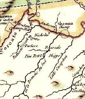
Piss Pot Island is an island on the South Branch Potomac River west of Romney in Hampshire County, West Virginia. Piss Pot Island received its unflattering name before 1755, the year it was included on Joshua Fry's and Peter Jefferson's Carte de la Virginie et du Maryland. Uncommon for islands of its size and geologic nature, Piss Pot Island has remained approximately the same size since the eighteenth century. The island is forested primarily with American sycamores and silver maples. It continues to be popular with fishermen and canoers on the South Branch Potomac River. Mill Creek empties into the South Branch to its western shore and Wergman Run enters the river to its northeast.
Contents
Map of Piss Pot Island, Romney, WV 26757, USA
Piss Pot Island is currently owned by the Williams family of Sycamore Dale, the historic brick plantation house located to its east on South Branch River Road (County Route 8). It is easily viewed from the Northwestern Turnpike (U.S. Route 50) in Vanderlip and the Romney Bridge.