
Elevation 2,022 m | ||
 | ||
Similar Petros, Brebeneskul, Hoverla, Rebra, Hutyn Tomnatyk | ||
Pip ivan chornohora timelapse
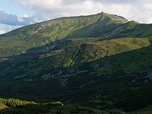
Pip Ivan (Ukrainian: Піп Іван; Polish: Pop Iwan) is the third highest peak (after Hoverla and Brebeneskul) of the Chornohora (Czarnohora) range, with height of 2022 meters (6,634 ft) above sea level.
Contents
Map of Pip Ivan, Ivano-Frankivska, Ukraine
In the interwar period (1918–1939) the peak marked the Polish - Czechoslovak, from March 1939 Polish - Hungarian border and numerous skirmishes between OUN and Polish border troops took place in the area.
On the peak of Pop Iwan, Polish government built in the years 1936–1938 an impressive construction - Astronomical and Meteorogical Observatory, which was commonly called "Biały Słoń" ("White Elephant"). Today, the construction is in ruins.
Now, Pip Iwan, together with the Chornohora range, is located in Ukraine.
References
Pip Ivan (Chornohora) Wikipedia(Text) CC BY-SA