
Basin area 376 km² | ||
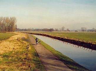 | ||
The Pinnau is a 41 km (25 mi) long river, which flows right or northeast of the main river, Elbe. The Pinnau is therefore a tributary in the southern part of Schleswig-Holstein. The Pinnau is categorized by German Bund/Länder-Arbeitsgemeinschaft Wasser (Federal/state association water) by "flow type" as a "marshland water body".
Contents
- Map of Pinnau Germany
- RouteEdit
- HydrologyEdit
- Tributary riversEdit
- HistoryEdit
- Federal Water StreetEdit
- References
Map of Pinnau, Germany
RouteEdit
The Pinnau has its source in the town of Henstedt-Ulzburg, then flows southwest, in Pinneberg to the west and ends in the municipality of Haselau in the Elbe, which streams in northwestern direction.
HydrologyEdit
The Pinnau is very much tide dependent and strongly influenced by tidal range.
Tributary riversEdit
HistoryEdit
The Pinnau was called in earlier times Ütristina or in later times Aue to Ueterst.
Federal Water StreetEdit
The Pinnau is a federal waterway within the remit of Waterways and Shipping Office Hamburg from the south-western edge of the railway bridge in Pinneberg to the mouth of the Elbe Page Sander addition with 18.81 km, at Elbe - km 658.99. It is one of the inland waterways, on which the Maritime Traffic Regulations applies.