Area 2,329 km² | Time zone China Standard (UTC+8) | |
 | ||
Country People's Republic of China Points of interest Sanping Temple, Pinghe Sanping Scenic Ar, Lingtongyan Scenic Area | ||
Pinghe County (simplified Chinese: 平和县; traditional Chinese: 平和縣; pinyin: Pínghé Xiàn; Pe̍h-ōe-jī: Pêng-hô-koān) is a county of the prefecture-level city of Zhangzhou, in southern Fujian province, PRC.
Contents
- Map of Pinghe Zhangzhou Fujian China
- Administrative Division
- Towns zhen
- Townships xiang
- Economy
- Tulou
- References
Map of Pinghe, Zhangzhou, Fujian, China
Administrative Division
The administrative centre or seat of Pinghe County is Xiaoxi (小溪) Town.
Towns (镇, zhen)
Most of Pinghe's old People's communes, after spending the 80s and even 90s as Townships, have been upgraded to Towns. Aside of Xiaoxi, there are now nine:
Townships (乡, xiang)
There are five townships.
Economy
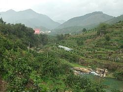
Pinghe County is famous for its pomelos.
Tulou
Numerous Fujian Tulou, earth buildings of round, rectangular and other shapes, can be found within Pinghe County, primarily in its western part (viz., various villages of Luxi, Xiazhai, Jiufeng and Daxi Towns). One of them, the Xishuang Lou (西爽楼), located in Xi'an Village a few kilometers north of Xiazhai town center, has been described by some researchers as the "largest of the rectangular [tulou] in existence". Unfortunately, only parts of the compound have survived to this day.
