
- elevation 11 m (36 ft) - elevation 0 m (0 ft) | ||
 | ||
The Pine River is a small river in South East Queensland, Australia.
Contents
Map of Pine River, Mission River QLD, Australia
The river is formed by the confluence of the North Pine and the South Pine rivers at Lawnton, continuing into Bramble Bay. The Brisway map reference is 440 D10.
Location and features
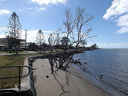
The Pine River carries the city border between the Moreton Bay Region and City of Brisbane along its middle (continuing up the South Pine River). The northern shoreline follows Pine Rivers suburbs of Murrumba Downs and Griffin, while the southern shoreline follows Brisbane suburbs of Bald Hills and Brighton. The river descends 11 metres (36 ft) over its 7-kilometre (4.3 mi) course. The Bald Hills Creek feeds into the Pine River which create the Bald Hills Creek and Tinchi Tamba Wetlands Reserve, a large environmental park covering more than 380 hectares (940 acres). The Pine River and Hays Inlet wetland is significant because of its value to wildlife, especially migratory waders. The Pine River is classified as being 'extensively modified'.
The Pine Rivers Shire draws its name from the Pine, the North Pine and the South Pine rivers.
Flora species
The predominant land uses in the catchment area are native bush, grazing, rural residential and urban.
Human uses
Water Supply: North Pine Dam North Pine Dam (Lake Samsonvale) is located on the North Pine River. The storage capacity for water supply is 215,000 megalitres (7,600×10^6 cu ft).
Recreational fishing: Pine river is a popular waterway for recreational fishing. Total estimated recreational catch for Pine River in 1997 was 1,509,755 fish (2.71% of Qld total) from an estimated 141,092 fishing trips (1.31% of Qld total). Estimated catch by top five species included; Whiting 351,799, Bream 230,598, Winter Whiting 203,028, Diver Whiting 190,131, Snapper (Squire) 127,298. (Data for 1999)
A maximum of ten commercial boats fished Pine River in 1999, for a total catch of 21.9 tonnes (21.6 long tons; 24.1 short tons). Pine River is also used for other water based recreation including water skiing and the use of personal water craft.