
 | ||
Piloting (on water) or pilotage (in the air also British English) or land navigation is navigating, using fixed points of reference on the sea or on land, usually with reference to a nautical chart, aeronautical chart or topographic map, to obtain a fix of the position of the vessel, aircraft or land traveler with respect to a desired course or location. Horizontal fixes of position from known reference points may be obtained by sight or by radar. Vertical fixes of position may be obtained by depth sounder or by altimeter. Piloting is usually practiced close to shore or on inland waterways. Pilotage is practiced under visual meteorological conditions for flight. Divers use related techniques for underwater navigation.
Contents
Instruments used
On shipboard, navigators may use a pelorus to obtain bearings, relative to the vessel, from charted objects. A hand bearing compass provides magnetic bearings. On land a hand compass provides bearings to landmarks.
Afloat
Mariners use position-fixing navigation, to obtain a "position fix" or "fix" by measuring the bearing of the navigator's current position from known points of reference. A visual fix of position can be made by using any sighting device with a bearing indicator to obtain position lines from the navigator's current position to each point of reference. Two or more objects of known position are sighted as points of reference, and the bearings recorded. Bearing lines or transits are then plotted on a chart through the locations of the sighted items. The intersection of these lines is then the current position of the navigator.
Usually, a fix is where two or more position lines intersect at any given time. If three position lines can be obtained, the resulting "cocked hat", where the 3 lines do not intersect at the same point, but create a triangle where the vessel is inside, gives the navigator an indication of the accuracy in the three separate position lines.
If two geographic features are visually aligned (the edge of an island aligned with the edge of an island behind, a flag pole and a building, etc.), the extension of the line joining the features is called a "transit". A transit is not affected by compass accuracy, and is often used to check a compass for errors.
The most accurate fixes occur when the position lines are at right angles to each other.
Aloft
Flying at low altitudes and with sufficient visibility, aircraft pilots use nearby rivers, roads, railroad tracks and other visual references to establish their position.
Course versus ground track
The line connecting fixes is the track over the ground or sea bottom. The navigator compares the ground track with the navigational course for that leg of the intended route, in order to make a correction in "heading", the direction in which the craft is pointed to maintain its course in compensation for cross-currents of wind or water that may carry the craft off course.
Piloting in channels and rivers
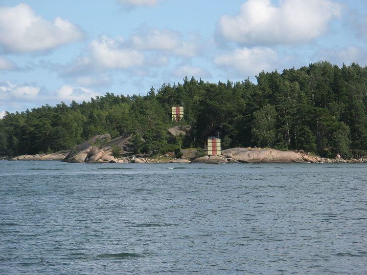
Where a channel is narrow, as in some harbor entrances and on some rivers, a system of beacons allows mariners to align pairs of daymarks, called "range markers", to form a "leading line" (British English) or "range axis" (American English), along which to navigate safely. When lighted, these markers are called "leading lights" (British English) or "range lights" (American English). The relative positions of the marks and the vessel affect the accuracy of perceiving the leading line.
Outside links
American Practical Navigator – Chapter 8: Piloting