
 | ||
Similar Nidaros Cathedral, Dovrefjell, Sister Churches - Norway, Dovrefjell–Sunndalsfjella National Park, St Olav's University Hospital | ||
Hiking in norway the pilgrim s route from oslo to nidaros walking 700 km of ancient trails
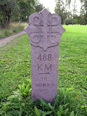
The Pilgrim's Route, (Pilegrimsleden) also known as St. Olav's Way or the Old Kings' Road, was a pilgrimage route to the Nidaros Cathedral in Trondheim, Norway, the site of the tomb of St. Olav. The main route is approximately 640 kilometres (400 mi) long. It starts in the ancient part of Oslo and heads north along the lake Mjøsa, up the Gudbrandsdal valley, over the Dovrefjell mountains, and down the Oppdal and Gauldalen valleys to end at the Nidaros Cathedral in Trondheim.
Contents
- Hiking in norway the pilgrim s route from oslo to nidaros walking 700 km of ancient trails
- The camino de santiago a pilgrim s journey
- Route
- Oldest Known Route
- Kings Way
- Present day route
- Shelters
- History
- Kings
- Railway lines
- References
The camino de santiago a pilgrim s journey
Route
Although the Pilgrim's Route over the Dovrefjell mountains is only one of several Old Kings' Roads in Norway, it is arguably the most famous. It connected the historically important cities of Oslo and Nidaros (now Trondheim) in Norway.
Oldest Known Route
The oldest known route over the Dovrefjell mountains went up to the east of the later "King's Way", leaving the valley of the Lågen at the Tofte Kongsgården (King’s Farm) just past the Dovre Church in the municipality of Dovre (slightly south of present-day Dombås). It followed a lower and more easterly route which followed the drainage to the east of Tofte, and then proceeded over Dovrefjell to join the route in Oppdal municipality.
King's Way
The "King's Way" traveled up through the Gudbrandsdal valley and left the valley of the Lågen at Tofte Kongsgården (King’s Farm) shortly past the Dovre Church in the municipality of Dovre (just south of present-day Dombås). This route went more directly over the Dovrefjell mountains into the municipality of Oppdal.
Present-day route
The "King's Way" route fell from use with the arrival of the railroad, but has recently been revived and is used by modern pilgrims and as a long-distance trail. There is a Pilgrim's Office in Oslo which gives advice to pilgrims and a Pilgrim Centre in Trondheim, under the aegis of the Nidaros Cathedral, which awards certificates to successful Pilgrims upon the completion of their journey.
Shelters
The historically heavy stream of pilgrims which visited the shrine of St. Olaf in Trondheim annually prior to the Reformation resulted in the erection of mountain stations (Norwegian: fjellstue) where the pilgrims could find food and shelter. Stations were erected at Kongsvoll, Drivstuen, Fogstuen, and later at Hjerkinn.
In speaking of the route, Knut Gjerset quotes Peder Claussøn Friis as writing in the late 16th century, "But in the winter people of high estate, as well as members of the court, travel mostly this way, because however high and deep the snow may fall, it blows together on the high mountains and becomes so hard men and horses can walk on it. The bonder [farmers] run over it on skis and snow-shoes. There are three stations: Drivstuen, Herdekinn and Fogstuen built on this same mountain in order that travelers may find lodging there...at the stations there are implements and dry wood, so that the traveler may build themselves fire, and not suffer from cold, when they have to remain over night, and cannot find the way across the mountain."
History
There is clear evidence that this route saw heavy use in the early Norwegian Iron Age. Oppdal on the route was located at a crossroads for traffic from Trondheim, the traffic over the Dovrefjell mountain range, and the west coast. At Oppdal there are over 700 Viking era grave mounds. This indicates that the Viking trade routes passed through these valleys.
It is appropriately termed "The King's Road". Virtually every king of Norway traveled this road. Those for whom we easily find records of their passage range from the first King of Norway through the last King able to pass that way before the road was completely replaced with modern rail and tarmac.
Harald Fairhair or Harold I was the first king of all Norway who crossed the Dovrefjell on The King's Road. Harald Hårfagres saga describes an expedition he led up the Gudbrandsdal, and north over Dovrefjeld on his way to success at the battle of Orkadal.
Kings
Railway lines
The Norwegian railway line Rørosbanen was opened on 13 October 1877, connecting Hamar and Trondheim via the towns of Elverum and Røros. At this point, pilgrims making the difficult route up through the Dovrefjell mountains lost most of its appeal, compared with the relative ease of taking a train to Trondheim.
The final end of the Old King's Road came on 17 September 1921, when the Dovre Line was completed. Starting at Dombås in Dovre municipality, it passes over the mountainous stretches of the Dovrefjell, before merging with the Rørosbanen again at Støren. It passes close to the Old King's Road's historic route, but is to the west along a route which, although longer, has a lesser grade, as is required for rail.