
Barangays ZIP code 2812 Local time Saturday 3:52 AM | Time zone PST (UTC+8) Area 66.1 km² | |
 | ||
Weather 21°C, Wind SE at 2 km/h, 85% Humidity | ||
Pilar, officially the Municipality of Pilar (Ilocano: Ili ti Pilar, Filipino: Bayan ng Pilar), is a municipality in the province of Abra in the Cordillera Administrative Region (CAR) of the Philippines. The population was 10,223 at the 2015 census. In the 2016 electoral roll, it had 6,843 registered voters.
Contents
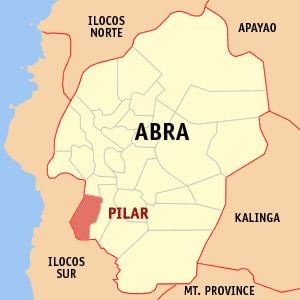
Map of Pilar, Abra, Philippines
Geography
Pilar is located at 17°25′N 120°36′E.
According to the Philippine Statistics Authority, the municipality has a land area of 66.10 square kilometres (25.52 sq mi) constituting 1.59% of the 4,165.25-square-kilometre- (1,608.21 sq mi) total area of Abra.
Barangays
Pilar is politically subdivided into 19 barangays.
Demographics
In the 2015 census, Pilar had a population of 10,223. The population density was 150 inhabitants per square kilometre (390/sq mi).
In the 2016 electoral roll, it had 6,843 registered voters.