
Location Lake Superior Highest elevation 438 m (1,437 ft) District Thunder Bay Elevation 438 m Province Ontario | Length 12 km (7.5 mi) Highest point Le Pate mesa Population uninhabited Area 46 km² | |
 | ||
Similar Mount McKay, Kaministiquia River, Sleeping Giant, Kakabeka Falls, Terry Fox Memorial and Look | ||
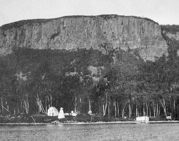
Pie Island, Ontario (French: Île Pâté, or simply Le Pâté) is an island in Lake Superior about 12 km (7.5 mi) long, 46 square kilometres in area, located about 10 km (6 mi) south of Thunder Bay and 25 km (15 mi) north of Isle Royale, Michigan. Pie Island is readily visible from the shoreline and high parts of the city of Thunder Bay.
Contents
- Map of Pie Island Neebing ON Canada
- Name Le Pt MesaEdit
- Mining and AgricultureEdit
- LighthouseEdit
- Fort William First Nation Land ClaimEdit
- References
Map of Pie Island, Neebing, ON, Canada
When a municipality was created in 1873 by the Ontario Legislature to govern the settlements around Thunder Bay, Pie Island was included in the Municipality of Shuniah. It formed part of Island Ward until 1936 when the Island Ward was abolished by the Ontario Legislature.
There are a number of summer cottages located on the southern tip of the island.
Name Le Pâté MesaEdit
The English name 'Pie' is an approximate translation of the French Le Pâté, which normally refers to a meat pie with a crust. "Le Pate is the westernmost mesa on Pie Island, and also the highest. Formed by a diabase sill, the mesa is cliffed on all sides and rises to a height of 1460 ft. (438 m) above sea level. Most of the mesa is flat on the top, but towards the edges begin to slope downwards. Also, there are several gullies which dissect the mountain top. Vegetation has been left to mature, owing to the inaccessibility of Pie Island to normal human traffic and the difficult climb to the top of the mesa. Wind is a major factor governing the height and form of vegetation on the mesa." [Noble 1980]
Mining and AgricultureEdit
In the 19th century the island was extensively prospected for silver. Algoma M.P. Simon James Dawson had a mine there (location no 19). Augustine W. Daby of Massachusetts took charge of the Pie Island Silver Mining Company in July 1881 until its sale by sheriff in February 1884 and November 1885. John McKellar also mined there. Lawyer Francis Henry Keefer, a son-in-law of Daby, and his brother Thomas Keefer had a farm where they grew hay as early as 1888. Keefer Point and Dawson Bay on the island are named after the two politicians.
LighthouseEdit
A lighthouse was established here in 1895 at the west end of the island. In July 1904, the Dominion government relocated the lighthouse to the north point of the island so that it could be seen for a greater distance. It has been replaced with a light on a five-metre skeletal tower. The original lighthouse was demolished in the summer of 2010, after being abandoned since 1953.
Fort William First Nation Land ClaimEdit
Pie Island falls within the land claim of the Fort William First Nation, who were allocated reserve lands in the Robinson Treaty of 1850. Negotiations have been going on between Canada, Ontario and the First nation since 2000. Ontario is proposing to transfer the provincial Crown land on Flatland Island and Pie Island, including Le Pate Provincial Nature Reserve (250 ha), to Canada to be set apart as reserve for Fort William First Nation. Privately owned land would not be subject to the land claim.