
Country Philippines Barangays ZIP code 2806 Local time Friday 8:07 PM | District Lone District of Abra Time zone PST (UTC+8) Area 49.15 km² Province Abra | |
 | ||
Region Cordillera Administrative Region (CAR) Weather 27°C, Wind SW at 2 km/h, 77% Humidity | ||
Abra 360 pidigan abra
Pidigan, officially the Municipality of Pidigan (Ilocano: Ili ti Pidigan, Filipino: Bayan ng Pidigan), is a municipality in the province of Abra in the Cordillera Administrative Region (CAR) of the Philippines. The population was 12,185 at the 2015 census. In the 2016 electoral roll, it had 7,980 registered voters.
Contents
- Abra 360 pidigan abra
- Map of Pidigan Abra Philippines
- Bobby parks son of pidigan abra
- Geography
- Barangays
- Demographics
- References
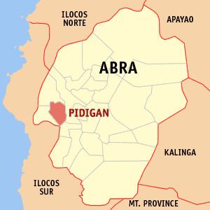
Map of Pidigan, Abra, Philippines
Bobby parks son of pidigan abra
Geography
Pidigan is located at 17°34′N 120°35′E.
According to the Philippine Statistics Authority, the municipality has a land area of 49.15 square kilometres (18.98 sq mi) constituting 1.18% of the 4,165.25-square-kilometre- (1,608.21 sq mi) total area of Abra.
Barangays
Pidigan is politically subdivided into 15 barangays.
Demographics
In the 2015 census, Pidigan had a population of 12,185. The population density was 250 inhabitants per square kilometre (650/sq mi).
In the 2016 electoral roll, it had 7,980 registered voters.