
Topo map NTS 012/H05 Elevation 545 m | Easiest route class 2 scramble Prominence 545 m Mountain range Long Range Mountains | |
 | ||
People also search for Mount Musgrave, The Cabox, Morne de la Grande Montagne, Tablelands | ||
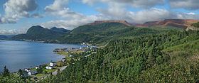
Pic a Tenerife (/tɛnəˈriːf/; [teneˈɾife]) is a mountain located in western Newfoundland, near the coastal community of Glenburnie in Gros Morne National Park. It is 545 m (1,788 ft) high and was named by Captain James Cook in 1767. It takes its name from the island of Tenerife in Spain.
Map of Pic a Tenerife, Division No. 9, Subd. A, NL, Canada
References
Pic a Tenerife Wikipedia(Text) CC BY-SA