
Highest point La Om Mountains La Om | ||
 | ||
Similar | ||
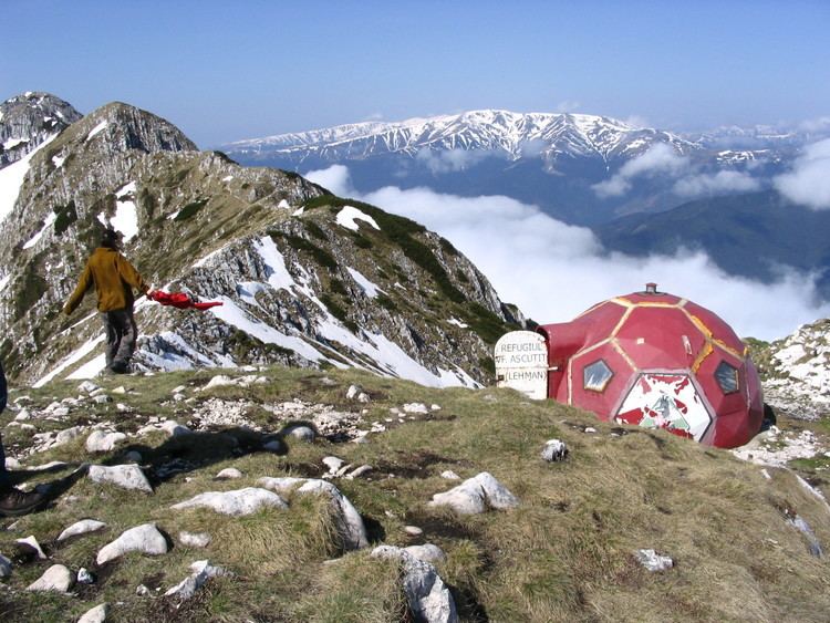
The north face of piatra craiului mountains romania pictures
The Piatra Craiului Mountains are a mountain range in the Southern Carpathians in Romania. In Romanian "Piatra Craiului" means "Prince's Stone".
Contents
- The north face of piatra craiului mountains romania pictures
- Map of Piatra Craiului Mountains Romania
- Location
- Nature protection
- Access
- References
Map of Piatra Craiului Mountains, Romania
The Piatra Craiului mountains form a narrow and saw-like ridge, which is about 25 km (16 mi) long. The highest elevation in the massif is the "Vârful La Om" at 2,238 metres (7,343 ft).
The ridge is regarded as one of the most beautiful sites in the Carpathians. The two-day north–south ridge trail is both challenging and rewarding. Starting at either Plaiul Foii in the north-west or Curmătura in the north-east, walkers climb up to the ridge before following a somewhat precarious path along the narrow spine. The descent at the southern end leads into a karst landscape of deep gorges and pitted slopes where water penetrating the rock has carved a series of caves.
Location
The massif is bordered in the west by the Dâmbovița Valley which separates it from the Iezer-Păpuşa massif; in the north-west the river Bârsa and Curmătura Foii separates it from the Făgăraș Mountains and in the east the "Rucăr-Bran Passage" delimits it from the Bucegi and Leaotă mountains. The southern border is the confluence of the valleys of Dâmbovița and Dâmbovicioara rivers, in the "Podul Damboviței" depression.
Nature protection
The whole range is included in the national park Parcul Național Piatra Craiului (Piatra Craiului National Park).
The first protection of this area started in 1938 when 4.4 km2 (2 sq mi) were declared as a "Nature Reserve". The Law 5/2000 enlarged this area to 148 km2 (57 sq mi). In 2003 the external limits and internal zoning were created. Since 1999 a park administration has existed and since 2005 a management plan has been in place.
In the national park area about 300 fungi species, 220 lichen species, 100 different mosses, 1100 species of superior plants (a third of the number of all plant species found in Romania), 50 Carpathians endemic species and also two endemic species for Piatra Craiului can be found.
There are also two endemic species of spiders, 270 butterfly species, amphibians and reptiles, 110 bird species (50 listed in the Bern Convention and 6 in the Bonn Convention), 17 bat species, chamois and other large herbivores and also many large carnivores (wolves, brown bears, lynx) living in the national park.
Access
Zărneşti is the most important town for visiting the national park. It is also an ideal starting point for approaches in the northern part of the massif. This town lies at a distance of 28 km (17 mi) from the city of Braşov, by road, bus or railway. From Zărnești, an 11 km (7 mi) long road makes the connection with the comfortable chalet "Plaiul Foii", which is a good starting point for climbing the ridge.
Also, from Zărnești a forest road starts from the south-western part of the town, leading through the Zărnești Gorges (Prăpăstiile) and further up to the ridge.
In Zărnești the office of the administration of the National Park can be found. A new visitor center has been built 1 km (1 mi) west of the town.
The traditional villages Măgura, Peştera, Ciocanu, and Şirnea are interesting starting points for the routes on the eastern slope and for getting in touch with the traditional Romanian way of life.