
Country Thailand Time zone ICT (UTC+7) Area 1,006 km² Geocode 6307 | Seat Phop Phra Postal code 63160 Province Tak Province | |
 | ||
Phop Phra (Thai: พบพระ, [pʰóp pʰráʔ]) is a district (amphoe) in the southwestern part of Tak Province, western Thailand.
Contents
- Map of Phop Phra District Tak Thailand
- History
- Etymology
- Geography
- Language
- Miscellaneous
- Administration
- References
Map of Phop Phra District, Tak, Thailand
History
The whole area of Phop Phra was originally Tambon Chong Khaep of Mae Sot district. Due to the large size of Mae Sot and problems with communist insurgents, the government created a separate administration for the area. Effective 1 April 1977 the three tambon Phop Phra, Chong Khaep, and Khiri Rat formed the new minor district (king amphoe). It was officially upgraded to a full district on 3 March 1987.
Etymology
The name "Phop Phra" means "Lord Buddha image discovery". Originally the area was named Pho Pha (เพอะพะ), which in the Karen language means "swamp area", so the name was changed to have a better meaning.
Geography
Neighboring districts are (from the north clockwise) Mae Sot, Mueang Tak, Wang Chao of Tak Province, Ban Rai of Uthai Thani Province, Umphang of Tak Province again, and Kayin State of Myanmar.
Namtok Pha Charoen National Park is in the district. The park is known for its Pha Charoen waterfall with 97 tiers.
The important river of Phop Pra is the Moei River.
Language
The primary spoken language is central Thai; however, Northern Thai, Karen, Burmese, and Mong are also very common.
Miscellaneous
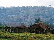
Along Mae Sot-Umphang Highway is a refugee center, Ban Um Piam (บ้านอุ้มเปี่ยม). It houses Karen refugees from Myanmar. They were relocated from the camp in Mae Sot close to Thai-Myanmar border which risked being attacked by guerrillas Democratic Karen Buddhist Army from Myanmar.
Administration
The district is divided into five subdistricts (tambon), which are further subdivided into 52 villages (muban). Phop Phra is a township (thesaban tambon), which covers parts of the tambon Phop Phra.
Subdistrict (tambon) Phop Phra is the capital of the district, with nine distinct villages. The District (Amphur) office is located here, as well as two offices responsible for administration of the subdistrict: a Tessabon, responsible for interior administration, primarily for villages 1,2, and 3, while the Subdistrict Administrative Organization (SAO) is responsible primarily for the outer villages. These outer villages are referred to as Huynamnak(4), Moonruchai(5), Moker Yang(6), Moo Jet(7), Moo Bpad(8), and Pakager(9). The Tessabon and SAO often work collaboratively to distribute services to all 9 villages.