
Primary inflows Basin countries Thailand Average depth 1.7 m (5.6 ft) Area 230 ha Mean depth 1.7 m Outflow location Ing River | Primary outflows Ing River Surface area 20.5 km (7.9 sq mi) Settlements Phayao Surface elevation 380 m Inflow source Ing River Cities Phayao | |
 | ||
Similar ท่าเรือวัดติโลกอาราม, Wat Si Khom Kham, Phu Chi Fa, Wat Rong Khun, Wat Phra Nang Din | ||
phayao lake 26k
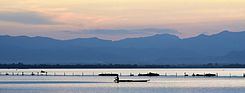
Phayao Lake (Thai: กว๊านพะเยา, rtgs: Kwan Phayao, [kwáːn pʰajaw]) is an semi-natural freshwater lake in northern Thailand. It covers an area of 12,831 rai (20.5 km²) at an elevation of 380 m. The lake has a mean depth of 1.7 m. The town of Phayao is at the southeast corner of the lake.
Contents
- phayao lake 26k
- Map of Phayao Lake Ban Sang Mueang Phayao District Phayao 56000 Thailand
- Phayao lake selfies the street dogs living in chiang rai thailand aditl btl ep15
- References
Map of Phayao Lake, Ban Sang, Mueang Phayao District, Phayao 56000, Thailand
The lake is fed by the Ing River, which empties to the north, and to a lesser degree by the Tam River, which empties into the south of the lake. At the east, the lake empties into the Ing River, which then flows to the Mekong. To the south and west of the lakes are rice paddies, at the mouth of the Ing River is marsh area.
The main aquatic plants in the lake are Najas graminea and Ceratophyllum demersum. Forty-eight species of fish are recorded for the lake, most dominant are the artificially introduced Nile Tilapia (Tilapia nilolica) and the climbing perch (Anabas testudineus). Also, 47 bird species were found at the lake in a survey in 1982.
The lake was created in 1939 to improve irrigation in the area. It was added to the list of 61 most important wetlands on 1 August 2000. There are currently plans to restore the ancient temple Wat Tilok Aram dating back to the end of the 15th century, which was submerged during the construction of the lake.