
Basin countries Vietnam Settlements Tam Kỳ Province Quang Nam Province Lake type Reservoir | Surface area 3,433 ha (8,480 acres) Area 34.33 km² Number of islands 30 Cities Tam Kỳ | |
 | ||
Location Phú Ninh District, Quảng Nam | ||
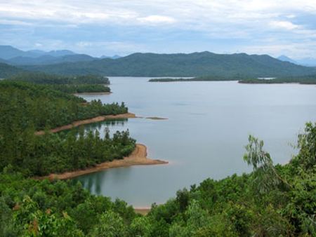
Lake Phú Ninh is an artificial lake in Phú Ninh District, Quảng Nam Province, Vietnam.
Contents
- Map of Phu Ninh Lake Quang Nam Province Vietnam
- Location
- Forest protection
- Topography
- Climate
- TerrainEcosystems
- Current land use
- Mineral water
- References
Map of Phu Ninh Lake, Quang Nam Province, Vietnam
Location
Lake Phú Ninh is 7 km south from Tam Kỳ Town, 70 km from Da Nang City and about 15 km from Chu Lai International Airport, Quảng Nam Province. On its banks are villages belonging to Phú Ninh District and Núi Thành District.
Forest protection
The total protective area surrounding Phú Ninh Lake is 23,409 ha, belonging to Phú Ninh and Núi Thành District. According to the Quảng Nam Forestry Bureau (in 2000), the area included 15,768 ha of forest including 1,500 ha of plantation forest. There is a great variety of animal and plant life, which are recorded in Vietnam's Red Data Book. It is the place to conserve hundred of plants and precious herbs with various zoology and plantation management systems. Phú Ninh Lake was recently awarded national historical heritage status.
Topography
The area is made up of low hills, average height 100–300 m, but some are 500–700 m above sea level. The average slope is 100 m, sloping to the west, south west and north east to form a small valley. To the south are mountain ranges with high peaks and sharp inclines which make this area strongly isolated. To the north and northwest are low mountains with easy slopes, creating many flat and large valleys surrounding Phú Ninh Lake.
The soil is mostly yellow-red feralite soil on sandstone (comprising app. 61.11% of the total) which is easily eroded and not conducive to growing vegetables and crops. Red yellow feralite soil on igneous rock (app. 20%) is often covered by forest. Fertile soil makes up the remaining 15-17% and exists in valleys along the springs where the residential areas and fields are concentrated.
Climate
Phú Ninh Lake's climate belongs to the Middle South climate area. It is not cold in autumn. Daily and yearly temperatures are both relatively low for Vietnam. There are two seasons: rainy and dry. The average readings taken at the Tam Kỳ weather station show the following characteristics:
Terrain/Ecosystems
Current land use
Mineral water
At the heart of the lake, near Chap Tra valley, there are many mineral water resources with useful elements for digestion and health improvement. The temperature of Phú Ninh's mineral water is 900C underground, 600C-700C when flowing out; the flowing speed is 0,5l/s. The mineral water company in Tam Ky commune uses it to make various products (planned output: 15 million bottles/year) However, they have not used this mineral water for medicinal purposes yet.