
Mountain range Sierra de Francia Parent range Sierra de Francia | ||
 | ||
Elevation 1,727 mPaso de los Lobos (1,499 m) Similar Pico Almanzor, Meseta Central, Calvitero, Peña Prieta, Canchal de la Ceja | ||
Santuario de nuestra se ora de la pe a de francia
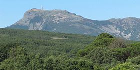
The Peña de Francia is a mountain that rises to 1,727 m, south of the Salamanca, Autonomous Region of Castile and León, Spain, whose peak belongs to the municipality of El Cabaco.
Contents
- Santuario de nuestra se ora de la pe a de francia
- Map of PeC3B1a de Francia 37532 Salamanca Spain
- Misterium la pe a de francia la monta a sagrada
- Location
- Geology
- Religion
- Views
- Flora
- References
Map of Pe%C3%B1a de Francia, 37532, Salamanca, Spain
Misterium la pe a de francia la monta a sagrada
Location
It belongs to the municipality of El Cabaco, it is one of the highest mountains of the Sierra de Francia, which in turn is part of the Central System. The synclinorium of the Peña de Francia is separated from syncline of Tamames by the granite outcrop of La Alberca. Surrounding the mountain to the north are towns that have become hotbeds of rural attractions during the last decade such as La Alberca.
Geology
Geologically it is a very complex structure and is one of the highest mountains of the western sector, namely the Sierra de Francia. It has a deformed structure with folds of various types, either highlighted by banks of Ordovician quartzites and conglomerates. These structures are located in an area near the Falla de Plasencia. The mountain is affected by dislocations to the North-East, along which there have been movements of blocks, and separating of different sectors of the folds.
Religion
Known for its Black Madonna, Our Lady of Peñafrancia, and its great Sanctuary of Our Lady of the Peña de Francia. It has a great influx of visitors during the summer months including many Christian pilgrims, but it is virtually inaccessible in the winter due to large amounts of snow. In addition the sanctuary, has a friary, a separate guest quarters for the monastery and a telecommunication antenna.
Views
From the top, the whole plain of Campo Charro is visible to the north, the Sierra de Tamames to the east, and the swamp of Gabriel and Galán to the south.
Flora
The vegetation at the bottom of the Mountain consists of Quercus pyrenaica , pine and Scots pine, ferns, and other species like Erica arborea and Erica australis , almost all of this reforestation is due to fires. In the upper layer is a remarkable presence of scrub such as Cytisus oromediterraneus Echinospartum and Pterospartum tridentatum .