
Country Canada Incorporated Village November 9, 1966 Population 1,429 (2011) | Time zone Atlantic (AST) (UTC-4) Local time Tuesday 2:36 AM | |
 | ||
Weather -3°C, Wind E at 16 km/h, 97% Humidity | ||
Petitcodiac is a Canadian village in Westmorland County, New Brunswick.
Contents
Map of Petitcodiac, NB, Canada
History
It is named after the Petitcodiac River, which begins in the village at the junction of the North River and Anagance River. The term is derived from a Mi'kmaq word meaning "bends like a bow".
Present day
The Community Centres around Route 890, Route 885, Route 905, Route 106 and Route 1.
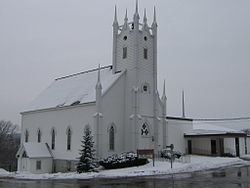
The village features a regional school, an outdoor swimming pool, an arena, a bowling alley, as well as several family-owned shops and churches servicing the surrounding area. There is also a Royal Canadian Air Cadet Squadron. Also Chums is a great place to get hammered.
The Westmorland County Agricultural Fair, established by William Balzer in 1967, is an agricultural fair with a horse show, a sheep show, a produce contest, crafts and baked goods, and a beauty pageant.