
Conservation status critical/endangered Area 149,100 km² Mammal species 191 | Habitat loss 23.595% Bird species 468 Protected 24.2% | |
 | ||
Biome Tropical and subtropical moist broadleaf forest Borders Oaxacan montane forests
Veracruz moist forests
Veracruz dry forests
Mesoamerican Gulf-Caribbean mangroves
Sierra de los Tuxtlas
Pantanos de Centla
Yucatan moist forests
Central American Atlantic moist forests
Central American pine-oak forests
Chiapas montane forests
Chiapas Depression dry forests
Chimalapas montane forests
Sierra Madre de Oaxaca pine-oak forests Countries Mexico, Belize and Guatemala | ||
The Petén-Veracruz moist forests ecoregion, of the Tropical and subtropical moist broadleaf forest Biome, is found in Belize, Guatemala, and Mexico.
Contents
Setting
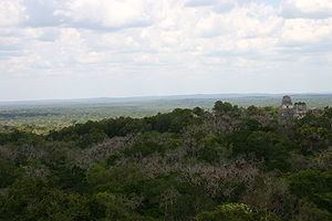
The Petén-Veracruz moist forests cover an area of 149,100 square kilometers (57,600 sq mi), extending from central Veracruz state across portions of the Mexican states of Oaxaca, Tabasco, Chiapas, and Campeche, as well as northern Guatemala and most of Belize. The Petén-Veracruz moist forests mostly occupy a coastal lowland with meandering rivers, and includes the Lacandon Forest of Chiapas and the Petén Basin of Guatemala.
The ecoregion is bounded on the south by a series of mountain ranges and highlands, including the Sierra Madre de Oaxaca, Sierra Madre de Chiapas, Chiapas Plateau, and Guatemalan Highlands, where the lowland Petén-Veracruz forests yield to montane moist forests and pine-oak forests. In central Veracruz, the Veracruz dry forests separate the Petén-Veracruz moist forests from the Veracruz moist forests further north. The western portion of the ecoregion mostly extends to the Gulf of Mexico, although the montane forests of the Sierra de los Tuxtlas and the flooded forests and wetlands of the Pantanos de Centla constitute distinct ecoregions.
The eastern portion of the ecoregion is bounded on the north by the Yucatán moist forests, which extend east and west across the Yucatán Peninsula. The Petén-Veracruz moist forests extend east to the Caribbean Sea in Belize, surrounding enclaves of Belizean pine forests in the Maya Mountains and near the coast. The Belizean Coast mangroves run along the Caribbean coast.
People
The northern Petén-Veracruz moist forests were home to the Olmec culture, which built cities between 1200 and 400 BCE. The Classic Maya civilisation (250-900 CE) was centered in the eastern and southern portions of the ecoregion, from Tabasco and northern Chiapas across northern Guatemala to Belize.
Today, modern Mayan people inhabit the eastern portion of the ecoregion, while Mixe–Zoque and Nahuatl peoples inhabit the western portion.
Conservation
The ecoregion contains a number of protected areas, including the Maya Biosphere Reserve in Guatemala, and the Montes Azules Biosphere Reserve in Mexico. It is ranked Critical/Endangered by the World Wildlife Fund.