
Area 57.47 km² | Primary inflows Basin countries United States Surface elevation 149 m Outflow location Stones River | |
 | ||
Surface area 14,200 acres (5,700 ha) Similar J Percy Priest Dam, Long Hunter State Park, Warner Parks, Tennessee Agricultural Museum, The Hermitage | ||
Bass fishing percy priest lake in nashville tennessee
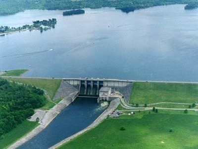
J. Percy Priest Lake is a reservoir in north central part of Tennessee. It is formed by J. Percy Priest Dam, located between miles six and seven of the Stones River. The dam (easily visible from Interstate 40) is located about 10 miles (16 km) east of downtown Nashville and impounds a lake 42 mi (68 km) long. The lake and dam are named for Congressman Percy Priest.
Contents
- Bass fishing percy priest lake in nashville tennessee
- Map of Percy Priest Lake Nashville TN 37076 USA
- Fox sports outdoors southeast 25 2016 percy priest lake tennessee bass fishing
- References
Map of Percy Priest Lake, Nashville, TN 37076, USA
The lake covers portions of Davidson, Rutherford and Wilson counties and consists of 14,200 acres (5,700 ha) of water at summer pool elevation 490 feet (150 m) above mean sea level. The water is surrounded by 18,854 acres (7,630 ha) of public lands; 10,000 acres (4,000 ha) are devoted to wildlife management. The site of the former town of Old Jefferson was inundated by the reservoir; the community was demolished in the early 1960s for the building of the dam.
The Percy Priest dam project was first authorized by the U.S. Congress in 1946 under the name “Stewarts Ferry Reservoir.” An act of Congress approved July 2, 1958, changed the name to honor Congressman Priest. The U.S. Army Corps of Engineers project was completed in 1967.
The dam, powerhouse, lake and public lands are operated and supervised by the Corps of Engineers' Nashville District personnel. The Natural Resource Management Office maintains three campgrounds (Anderson Road, Seven Points and Poole Knobs), eleven day-use/picnic areas (Anderson Road, Cook, Damsite, East Fork, Fate Sanders, Jefferson Springs, Nice's Mill, Overlook, Seven Points, Smith Springs and Tailwater) and twelve boat launching ramps (Anderson Road, Cook, East Fork, Fall Creek, Fate Sanders, Hurricane Creek, Jefferson Springs, Lamar Hill, Mona, Nice's Mill, Poole Knobs, Seven Points, Smith Springs, Stewart's Creek and Viverett Creek). Marinas at the lake include Nashville Shores, Elm Hill, Four Corners, Fate Sanders, Hamilton Creek and Percy Priest. The lake is also home to a number of recreational organizations such as the Tennessee Boat Club, Percy Priest Yacht Club, Vanderbilt Sailing Club, the Vanderbilt Rowing Club and the Nashville Rowing Club.