
Highest point Spruce Mountain | Mountains Spruce Mountain | |
 | ||
Pequop mountains
The Pequop Mountains are a mountain range located in eastern Elko County, in northeastern Nevada in the western United States. The range runs generally north-south for approximately 51 miles (82 km). The high point of the range is an unnamed peak (9249 feet, 2819 m) located at 40°55.46'N and 114°35.38'W.
Contents
The range comprises two distinct groups of mountains, separated by a low line of hills at Flower Pass. To the west is Independence Valley and the East Humboldt Range, while to the east is Goshute Valley and the Toano Range. The southern section of the range, bending slightly to the southwest, essentially merges with Spruce Mountain, and is the location of the South Pequop Wilderness Study Area.
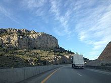
These mountains are a serious obstacle to travel between the more level terrain of the Great Salt Lake Desert and the Humboldt River Valley. The First Transcontinental Railroad was routed around the north end of the range, on its way to Promontory Summit in Utah. The later Western Pacific Railroad line, which crosses the Great Salt Lake Desert, tunnelled through the range at Flower Pass (which was itself part of the historic Hastings Cutoff route). Interstate 80 crosses the northern section of the range at 6,967 ft (2,124 m) Pequop Summit, its highest point between Parley's Summit in the Wasatch Mountains of Utah and Donner Summit in the Sierra Nevada Range of California.