
Elevation 1,813 m Mountain range Sistema Ibérico | Province Province of Castellón Parent range Sistema Ibérico | |
 | ||
Easiest route Drive from Vistabella del Maestrat Similar Cerro Calderón, Puig Campana, Montgó Massif, Montcabrer, Aneto | ||
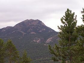
Penyagolosa ([ˌpeɲaɡoˈloza], Spanish: Peñagolosa) is a mountain in the Alcalatén area, Valencian Community, Spain. Geologically it is part of the Iberian System, located at the eastern end of Iberian Peninsula. Its peak is at 1,813 meters above sea level and is often crowned with snow in the winter.
Contents
Map of Penyagolosa, 12124, Castell%C3%B3n, Spain
The Penyagolosa is widely considered to be most emblematic mountain in the Valencian Community. Since it stands quite isolated, it was thought to be the highest peak in the region, but actually the highest is the 1,839 meter high Cerro Calderón, located in the Rincón de Ademuz, a Valencian exclave where there are three more peaks over 1,500 m.
At the base of the mountain is the important pilgrimage destination of Sant Joan de Penyagolosa.
Penyagolosa Massif
The Penyagolosa Massif includes other minor mountain ranges, like the Sierra de la Batalla which stretches westward towards Aragon.