
Population 357 (2001) Area 90 km² | Ethnic groups Polynesian Archipelago Cook Islands | |
 | ||
Location Central-Southern Pacific Ocean | ||
Penrhyn (also called Tongareva, Mangarongaro, Hararanga, and Te Pitaka) is an island in the northern group of the Cook Islands in the south Pacific Ocean. The northernmost island in the group, it is located at 1,365 km (848 mi) north-north-east of the capital island of Rarotonga, 9 degrees south of the equator. Its nearest neighbours are Rakahanga, and Manihiki, approximately 322 kilometres (200 mi) to the southwest.
Contents
- Map of Penrhyn Kiribati
- Geography
- Etymology
- Villages
- History
- Slavery
- Foreign claims
- World War II
- Cyclone Pat
- References
Map of Penrhyn, Kiribati
Geography
Penrhyn is a roughly circular coral atoll with a circumference of approximately 77 km (48 mi), enclosing a lagoon with an area of 233 square kilometres (90 sq mi). The atoll is atop the highest submarine volcano in the Cook Islands, rising 4,876 metres (15,997 ft) from the ocean floor. The atoll is low-lying, with a maximum elevation of less than 5 metres (16 ft). The total land area was 9.84 square kilometres (3.80 sq mi). The population according to the 2001 census was 351 inhabitants, with a decrease by 2011 to only 213 inhabitants.
Etymology
Penrhyn's original name was Tongareva. Academic research published by the Cook Islands Library and Museum says this is variously translated as "Tonga floating in space", "Tonga-in-the-skies" and "A way from the South". However, the most commonly used name in English is Penrhyn after the Lady Penrhyn commanded by Captain William Crofton Sever, who passed by the island on 8 August 1788. Penrhyn means "peninsula" in Welsh. Another European name was Bennett Island. Lady Penrhyn was one of a fleet of 11 ships which sailed from the Isle of Wight (off the south coast of the UK) to found the earliest convict colony in Australia.
Villages
Penrhyn Atoll has two villages. The main village of Omoka, seat of Penrhyn Island Council, is on Moananui Islet, on the western rim of the atoll, north of the airport. The village of Te Tautua is on Pokerekere Islet (also known as Pokerere or Tautua), on the eastern rim.
The inhabitants of the island are Christian, with 92% of the population belonging to the Cook Islands Christian Church while the remaining 8% adhere to the Roman Catholic Church.
History
Polynesians are believed to have lived on Penrhyn since at least 900 or 1000 AD. Following its discovery by Europeans, the Russian explorer Otto von Kotzebue visited the island in April 1816. He was followed by the American brig USS Purpose, under command of Lieutenant Commander Cadwalader Ringgold as part of the United States Exploring Expedition in February 1841. The brig Chatham under command of Edward Henry Lamont, ran aground at Penrhyn during a storm in January 1853. The London Missionary Society, which had begun missionary activities in the Cook Islands from 1821, sent a team to Penrhyn in 1854.
Robert Louis Stevenson visited Penrhyn in May 1890.
Slavery
In 1864, Penrhyn was almost completely depopulated by Peruvian expeditions. An estimated 1,000 men, women and children were taken to South America. Native pastors of the London Missionary Society had introduced Christianity from Rarotonga in 1854. The new religion had been accepted enthusiastically, and the villagers immediately started to build churches. Promises from the slavers of good pay and safe return offered a way to obtain money for churches, but all who accepted died in exile, virtually slaves.
Another source states that in 1863, 410 inhabitants out of a total population of about 500 were kidnapped by blackbirding by the Peruvian blackbirders who were assisted by four native missionary teachers, who sold their people for five dollars per head. The missionaries accompanied the slaves to Peru as their interpreters; none of the 'stolen people' ever returned.
Foreign claims
Penrhyn was officially annexed for Great Britain by Captain Sir William Wiseman of the HMS Caroline on 22 March 1888. The island was considered to have a strategic location on the route of a proposed Trans-Pacific telegraphic connection between Canada and Australia.
The Cook Islands were a British protectorate 1888 to 1900, when annexed to New Zealand, until independence in 1965 when residents chose self-government in free association with New Zealand.
From 1856 to 1980, the United States claimed sovereignty over the island under the Guano Islands Act. That claim had never been recognized by Britain, New Zealand or the Cook Islands and New Zealand sovereignty was recognized during World War II U.S. military operations involving the islands. On 11 June 1980, in connection with establishing the maritime boundary between the Cook Islands and American Samoa, the United States signed Cook Islands – United States Maritime Boundary Treaty acknowledging that Penryhn was under Cook Islands sovereignty.
World War II
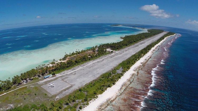
In early 1942 Japanese advances had placed the South Pacific air ferry route's initial path at some risk so that an alternate route was directed. In March Leif J. Sverdrup determined on a tour of potential island sites that Penrhyn was suitable and, though all land was owned by the local population and it was illegal to sell, use could be arranged and local labour could help build an airfield. Work on the airfield began in July 1942 with aviation gasoline storage tanks added to the completed field.During the war, US Navy PBY Catalina and USAAF B-24 Liberator bombers were stationed on the island and with about a thousand support personnel. A communications link through the island was established by the U.S. Army Signal Corps. American forces were withdrawn in September 1946.
The US Army vessel Southern Seas struck an uncharted reef on 22 July 1942 and was severely damaged with flooded engine rooms and abandoned in Taruia Pass while on an island charting assignment in support of the construction. The ship was later salvaged by the Navy and commissioned for naval use.
Cyclone Pat
In February 2010 much of Omoka was damaged by Cyclone Pat, but there were no serious casualties. Unfortunately the school was demolished and the community was left without teaching facilities. Tongareva's Women's Craft Guild loaned their meeting house, however, this meant that five classes ranging from 3–16 years old had to be taught in a single room: it was most challenging. New Zealand Aid paid completely for a new school to be constructed, Meitaki Poria.