
Existed: 1930 – present Constructed 1930 | Length 36.37 km | |
 | ||
Counties | ||
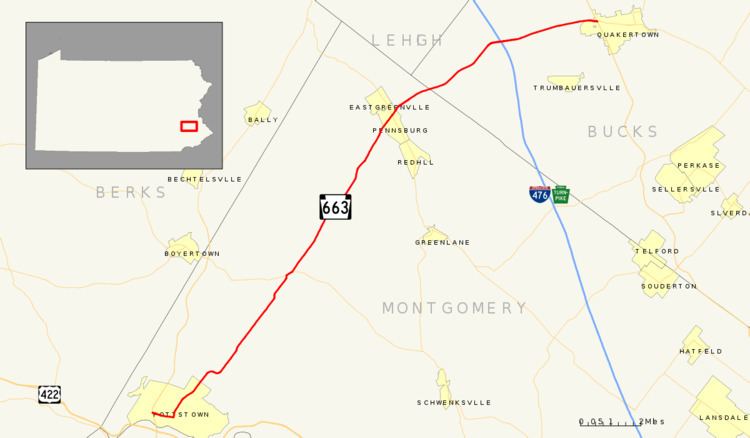
Pennsylvania Route 663 (PA 663) is a 22.13-mile-long (35.61 km) state highway in Bucks and Montgomery counties in southeast Pennsylvania. Its northern terminus is at PA 309 and PA 313 in Quakertown, where it continues eastward as PA 313, and its southern terminus is at PA 100 in Pottstown. Along the way, PA 663 also passes through the town of Pennsburg. It is called John Fries Highway between Pennsburg and Quakertown. It has an interchange with Interstate 476 (I-476, the Northeast Extension of the Pennsylvania Turnpike) at exit 44 west of Quakertown. The route was assigned in 1930, and it has had several realignments since its commissioning, including two major ones.
Contents
Map of PA-663, Pennsylvania, USA
Route description
PA 663 begins at an intersection with PA 100 in the borough of Pottstown in Montgomery County, heading east on four-lane undivided West King Street. The road passes through commercial areas and crosses the Colebrookdale Railroad and Manatawny Creek. The route becomes two-lane undivided King Street and is lined with residences. PA 663 turns north onto Charlotte Street and continues past homes, curving to the northeast. The road crosses into Upper Pottsgrove Township and runs through a mix of residential and commercial areas as North Charlotte Street. The route turns east before it curves back to the northeast. PA 663 continues through wooded areas with a few homes and enters New Hanover Township. The road runs through more rural areas with some development and passes to the east of New Hanover Airport at the Swamp Pike intersection.
Farther northeast, PA 663 intersects PA 73 and turns east to form a concurrency with that route on Big Road. The road crosses Swamp Creek before PA 663 splits from PA 73 by heading northeast on Layfield Road. The route runs through farmland and woodland with some development. Farther northeast, the road heads into Upper Hanover Township and crosses the Green Lane Reservoir along the Perkiomen Creek. PA 663 heads into the borough of Pennsburg, where it becomes Pottstown Avenue and runs past homes and a few businesses. In the center of town, the route intersects PA 29. Past this intersection, the road becomes Quakertown Avenue and passes more development before leaving Pennsburg for Upper Hanover Township again. At this point, the route becomes John Fries Highway and heads through farm fields and woods.
Past the Geryville Pike intersection, PA 663 enters Milford Township in Bucks County and continues through more rural areas. The road passes to the southeast of Spinnerstown and widens into a four-lane divided highway at the Spinnerstown Road/Krammes Road intersection, where it curves to the east. The route becomes undivided and comes to an interchange with I-476 (Pennsylvania Turnpike Northeast Extension). PA 663 becomes a divided highway again and passes businesses. The route becomes a two-lane undivided road again and continues back into rural areas, where it crosses Allentown Road. The road passes to the north of Milford Square and passes near some development. The route enters Richland Township at the Portzer Road intersection and passes homes, becoming the border between Richland Township to the north and the borough of Quakertown to the south at the Milford Square Pike intersection. PA 663 heads into commercial areas and fully enters Quakertown, where it widens back into a four-lane divided highway and comes to its northern terminus at an intersection with PA 309. Past this intersection, the road continues east as PA 313.
History
PA 663 was once part of the Steinsburg and Milford Square Turnpike. The turnpike was chartered in March 1858. When Pennsylvania legislated routes in 1911, what is now PA 663 was not given a number. PA 663 was designated in 1930 to run from in US 422 (High Street) in Pottstown north to PA 73 in New Hanover Township. At this time, the entire length of the route was paved, along with the unnumbered road between PA 73 and Quakertown. In 1936, PA 663 was extended north to an intersection with PA 309 and PA 313 in Quakertown. The route followed its current alignment between PA 73 and Pennsburg before it followed Quakertown Road and Sleepy Hollow Road to Spinnerstown, where it turned east and followed Spinnerstown Road and Milford Square Pike to Quakertown. By 1967, the southern terminus of PA 663 was rerouted to PA 100 in Pottstown, heading west on King Street. In the 1960s, PA 663 was shifted from Milford Square Pike to a new alignment to the north between the Northeast Extension and Quakertown. After construction began in 1973, a new alignment of PA 663 to the south from Pennsburg to the Northeast Extension opened a year later, with the route moved off Quakertown Road, Sleepy Hollow Road, and Spinnerstown Road.
Pottstown
Pennsylvania Route 663 Alternate Truck is a truck route around a weight-restricted bridge over the Manatawny Creek in Pottstown, on which trucks over 25 tons and combination loads over 28 tons are prohibited. It follows PA 100, North State Street, and Manatawny Street and was signed in 2013.
Upper Hanover Township
Pennsylvania Route 663 Alternate Truck is a truck route around a weight-restricted bridge over a branch of the Perkiomen Creek in Upper Hanover Township, on which trucks over 36 tons and combination loads over 40 tons are prohibited. It follows PA 73, PA 100, and Kutztown Road and was signed in 2013.