
Length 35.2 km | Counties: Fayette Constructed 1928 | |
 | ||
North end: US 40 in Redstone Township County | ||
Pennsylvania Route 166 (PA 166) is a north–south state highway in Fayette County, Pennsylvania. It follows the path of the Monongahela River along the entire western border of Fayette County.
Contents
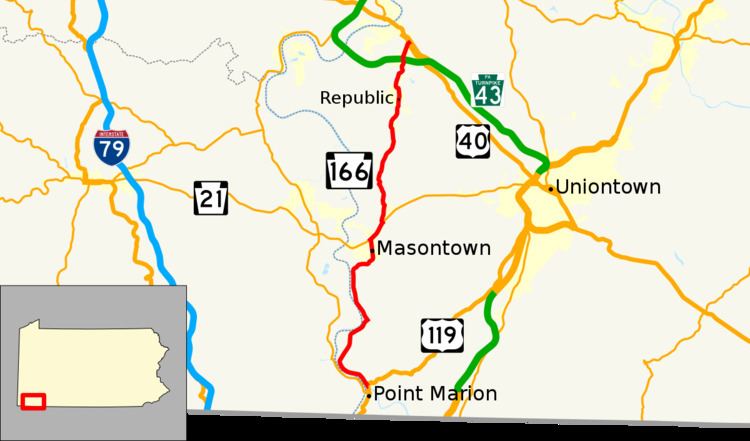
Map of PA-166, Pennsylvania, USA
Route description
PA 166 begins at an intersection with US 119 in Springhill Township just north of the confluence of the Monongahela and Cheat Rivers at Point Marion. From this point, PA 166 heads northwest on two-lane undivided New Geneva Road, following the Monongahela River downstream. The route passes through forested areas with a few homes and farms, turning north and reaching the Friendship Hill National Historic Site. The road turns northeast and runs through the community of Friendship Heights, crossing the George Creek into Nicholson Township. Here, the route passes through the residential community of New Geneva, with a CSX railroad line running in between the road and the Monongahela River. After passing through New Geneva, the road heads back into forests. PA 166 turns off of New Geneva Road and stays parallel to the Monongahela River, heading to the north on an unnamed road. The route continues through more wooded areas, passing through the residential communities of Martin, Gallatin, and Grays Landing. Upon crossing into German Township and curving northeast away from the river, PA 166 becomes Masontown Woodside Road and passes through more woodland. The road turns north and enters Masontown, becoming South Main Street and running past homes. The route heads into the commercial downtown and becomes North Main Street, heading past more residences in the northern part of town.
Upon crossing back into German Township, PA 166 comes to an interchange with PA 21, at which point the route heads northeast to form a concurrency with PA 21 on four-lane divided McClellandtown Road. The two routes head through a mix of farmland and woodland with some commercial development, passing through Lardin. PA 166 splits from PA 21 by heading north on two-lane undivided Edenborn Road into wooded areas. The route passes through the residential community of Edenborn before continuing north through forested areas with some homes on Ball Hill Road. PA 166 enters more wooded surroundings as it continues further north along Hartley Hill Road. Upon reaching the community of Hibbs, the road enters Redstone Township and becomes Thompson 1 Road, heading north through a mix of farmland and woodland with some homes. After passing the Thompson No. 1 mine, PA 166 continues into forests, becoming Tower Hill Road as it crosses into Luzerne Township. The road heads back into Redstone Township and passes through the residential community of Republic. Entering a patch of woods, the route crosses into Luzerne Township again and becomes Thornton Road as it serves the community of Allison. PA 166 heads into Redstone Township for a third time and heads through forested areas with a few homes, crossing the PA 43 toll freeway that is under construction. The route turns northeast into a commercial area and intersects US 40 Business, becoming four-lane divided Grindstone Road. A short distance later, PA 166 comes to its northern terminus at an intersection with US 40.
Major intersections
The entire route is in Fayette County.