
Length: 2.25 mi (3.62 km) Area 195 ha | Counties: Bronx Population 30,073 (2010) | |
 | ||
Restrictions: No commercial vehicles (trucks restricted to service road) Restaurants Cafe Colonial Restaurant, John & Joe's Pizzeria, EZ Grill NYC, Dukagjini Burek, Boe Lee Chinese | ||
muninyc pelham parkway white plains road pelham parkway bronx 10467
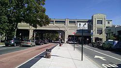
The Bronx and Pelham Parkway (usually referred to simply as Pelham Parkway) is a 2.25-mile (3.62 km) long parkway in the borough of the Bronx in New York City. Despite the parkway moniker, Pelham Parkway is a local street, with two main roadways (one in each direction), and two service roads. Like other parkways in New York City, commercial traffic is disallowed, and is redirected to the service roads. Pelham Parkway runs from the Bronx River Parkway (at a mutual junction with U.S. Route 1 or US 1 within Bronx Park) out to Pelham Bay Park, hence the name, as it connects the two parks. A bikeway runs alongside. At the eastern end, it intersects with Interstate 95 (I-95, named the New England Thruway at this point). Though the parkway ends here, the road itself continues as Shore Road. At its west end, it continues as East Fordham Road, then West Fordham Road (after passing Jerome Avenue) and in Manhattan as West 207th Street. The residential neighborhood that surrounds the parkway is known by the same name.
Contents
- muninyc pelham parkway white plains road pelham parkway bronx 10467
- Map of Pelham Parkway Bronx NY USA
- Route description
- Major intersections
- References
Map of Pelham Parkway, Bronx, NY, USA
Pelham Parkway is maintained by the New York City Department of Transportation, while the surrounding landscaping and bike path are managed by the New York City Parks Department. The parkway is designated as New York State Route 907F (NY 907F), an unsigned reference route, by the New York State Department of Transportation. The parkway was constructed from 1935 to 1937. A proposal put forth by Robert Moses recommended that the at-grade boulevard be upgraded to a limited access freeway in the 1950s. However due to Moses’ career coming to a close, the project never materialized. The parkway now handles approximately 35,000 vehicles per day.
Route description
The Pelham Parkway begins at an interchange with the Bronx River Parkway (exit 7W–E) in the Bronx Park section of The Bronx. An eastward continuation of East Fordham Road, the Pelham Parkway is six-lane divided parkway, crossing under the IRT White Plains Road Line at the Pelham Parkway station. The parkway continues east through the Bronxwood neighborhood, passing and intersecting with Williamsbridge Road. At this interchange, the Pelham crosses over the IRT Dyre Avenue Line. Leaving Bronxwood, the parkway bends eastward, crossing Eastchester Road, then Stillwell Avenue merges into the parkway.
After Stillwell Avenue, the parkway crosses over the Northeast Corridor and enters Pelham Bay Park. In the park, the Pelham enters a cloverleaf interchange with the Hutchinson River Parkway (exit 3). Less than 0.5 miles (0.80 km) later, the parkway enters a cloverleaf with I-95 (the Bruckner Expressway to the south, the New England Thruway to the north). This junction serves as the eastern terminus of the Pelham Parkway, which continues east into the park as Shore Road. The East Coast Greenway travels along Pelham Parkway and Shore Road.
Major intersections
The entire route is in the New York City borough of the Bronx.