
Basin size 75 sq mi (194 km) | Length 24 km Mouth elevation 0 | |
 | ||
Main source Brookhaven National Laboratory249 feet (76 m) Discharge Average rate:37 cubic feet (1 m)/second | ||
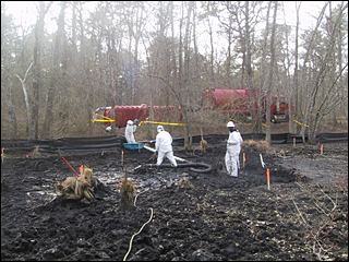
Thousands more dead fish found floating in peconic river
The Peconic River is a river within Suffolk County on Long Island, New York in the United States. The river is located in the eastern end of Long Island. The Peconic River drains an area between the Harbor Hill and Ronkonkoma terminal moraines, and flows into Flanders Bay which in turn connects to Peconic Bay east of Riverhead.
Contents
- Thousands more dead fish found floating in peconic river
- Map of Peconic River New York USA
- Peconic river kayak trip 8 23 11 part 1
- List of crossings of the Peconic RiverEdit
- References
Map of Peconic River, New York, USA
The river originates in bogs and wetlands in central Long Island near the Brookhaven National Laboratory and flows eastward to the Peconic Bay. It is the longest river on Long Island and is almost entirely within the Central Long Island Pine Barrens which was set up in 1993 to protect its relative wilderness standing.
It is fresh water until about the center of Riverhead where it becomes an estuary.
The river is slow-moving, making it ideal for canoers.
It forms the border between Brookhaven and Riverhead towns as well as the border between Riverhead and Southampton.