
 | ||
Beautiful larkton bickerton bulkeley peckforton hills
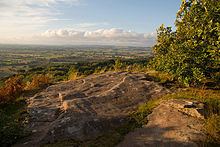
The Peckforton Hills are a sandstone ridge running broadly northeast–southwest in the west of the English county of Cheshire. They form a significant part of the longer Mid Cheshire Ridge which extends southwards from Frodsham towards Malpas.
Contents
Bulkeley Hill (grid reference SJ525552) stands at the south end, and the ridge is continued southwards by Bickerton Hill. The high points are Peckforton Point (SJ529557; 203 m), immediately north of Bulkeley Hill (224m), and Stanner Nab (SJ531573; 200 m), towards the northern end of the ridge.
Settlements around the hills include Burwardsley to the west, Beeston to the north, Peckforton and Bunbury to the east and Bulkeley to the south. On Ascension Day the parishioners of St Boniface, Bunbury walk to the 200m summit of Stanner Nab for a service as the sun sets.
Features
The Sandstone Trail long-distance footpath runs along the ridge, and the hills are the source of both the River Weaver and the River Gowy. A 57.88 hectares area of Peckforton Woods has been designated a Site of Special Scientific Interest. Bulkeley Hill is owned by the National Trust, and its wooded slopes include 12 acres (5 hectares) of semi-natural ancient woodland. Peckforton and Bulkeley Hills have also both been designated county sites of biological importance for their woodland and grassland habitats.
Peckforton Castle, a Victorian mansion built in the style of a medieval castle, stands at the northern end of the Peckforton ridge.