
Population 513 (2011 census) Postal code 2256 | Postcode(s) 2256 Area 120 ha Local time Saturday 11:14 PM | |
 | ||
Location 21 km (13 mi) S of Gosford9 km (6 mi) S of Woy Woy Weather 20°C, Wind N at 3 km/h, 94% Humidity | ||
Pearl Beach is a suburb of Central Coast Council on the Central Coast of New South Wales, Australia. Pearl Beach was assigned 'suburb' status by the Geographical Names Board of NSW on 25 October 1991.
Contents
- Map of Pearl Beach NSW 2256 Australia
- History
- Geography
- Swimming
- Environment
- Awards
- Community groups
- Community events
- Residential development
- Road
- Rock Pool
- Electricity
- Sports facilities
- Notable residents
- References
Map of Pearl Beach NSW 2256, Australia
History
Pearl Beach has a rich Indigenous history that is largely ignored by historical markers which have been erected in the community to commemorate visits by white settlers.
On 2 March 1788 Captain Arthur Phillip sailed north from Sydney Cove, Port Jackson, to the inlet described by Captain James Cook in 1770 as a "broken land" (id est Broken Bay). As entered in their journals:
Geography
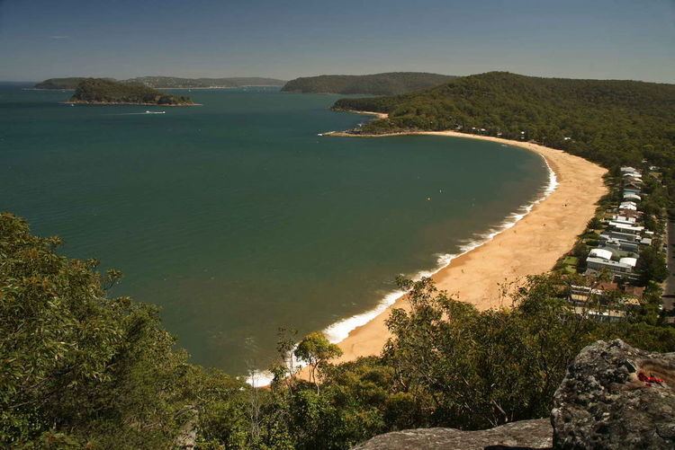
Located south of Umina Beach, being separated from it by a ridge upon which sits Mount Ettalong at a height of 56 metres (184 ft). It is bounded on the west and south by Brisbane Water National Park, and on the east by Broken Bay. Green Point, with Paul Landa Reserve, adjoins the southern end of the beach. The bay provides an example of a logarithmic spiral beach.
Swimming
The south end of the beach is placid, sheltered by a rocky point and Lion Island and is favoured by most visitors as a swimming spot. The north end of the beach is known for rough surf and is unofficially called "the dumpers". The dumpers, excluding the roughest waves at the far north end of the beach, are a popular bodysurfing spot for strong, confident swimmers, except during particularly rough surf or at king tide. Swimmers risk getting violently pounded onto the sand by a wave, or "chundered" (usually kayaking terminology) by waves dumping into a deep trench along the shoreline, but can generally avoid getting chundered by moving towards dry land or ducking under the break of the wave and swimming back to shore in smaller waves.
In 2014, five-year-old Chayce Kofe drowned after a wave swept him off the shore by a large wave. Gosford City Council continues to oppose danger signs despite calls from the local Member Kathy Smith to erect them.
Environment
Pearl Beach village is located within the National Trust of Australia's Broken Bay Entrance Landscape Conservation Area.
Awards
Community groups
The Pearl Beach Progress Association was formed in 1929 to work for the needs of local residents. Membership is available to anyone who is 16 years of age or older and lives in Pearl Beach, or are owners of property in Pearl Beach, and the immediate families of such persons.
Community events
Since 2006, Opera in the Arboretum has been performed annually in March in the Crommelin Native Arboretum. The event is organised by the Rotary Club of Woy Woy and features performances by leading Australian opera identities. All proceeds are given to charities and Rotary projects.
Residential development
Residential development in Pearl Beach is governed by Gosford City Council's Development Control Plan 162 (DCP16). The aim of the Control Plan is to preserve, improve and restore the special natural character of Pearl Beach. It applies to all properties in the village of Pearl Beach, including, proposed buildings and major alterations and additions to existing buildings. DCP16 has superseded Gosford City Council’s policies for Pearl Beach titled DO 16 and Pearl Beach Residential Development Policy.
Road
As of November 2010, Pearl Beach Drive is the only vehicular access road to the town.
The only other access is via the former Pearl Beach Road, also sometimes referred to as Cliff Road, which, nowadays, is a rocky unstable walking track that runs 30 feet above the shoreline around the base of the Mount Ettalong cliff via Umina Point. Pearl Beach Road is Heritage Listed, notably as a Section 2: Items listed by Local Government and State agencies.
Vehicular access to Pearl Beach has been problematic ever since motorised traffic was given access to the town, some events in this long saga include:
Rock Pool
In 1926 construction of the Rock Pool, located at the southern end of the beach, adjoining Green Point, commenced. Once completed in 1928, C. R. Staples and Co. used it in promotional material to help sell land. Up until 1950, the pool suffered a pollution problem from its own amenities block that used open uncovered sanitary pans. Design and maintenance problems have plague the pool from the start. Nonetheless many people have and still enjoy the rock pool. During 2010, the rock pool was closed for 4 months whilst major renovations were carried out.
Electricity
Plans to provide Pearl Beach with electricity were given an approval on 31 December 1936. Mr. R. Franki, consulting electrical engineer to the Woy Woy Council, was instructed to proceed with construction after the necessary number of guarantees had been signed by the residents.
Sports facilities
Two tennis courts and a narrow artificial turf bowling green are located in Opal Close, bookings required. Lap swimming is available at the rock pool located at the southern end of the beach.