
Time zone Pacific (PST) (UTC-8) Elevation 960 m Local time Saturday 4:59 AM | ZIP codes 93553 Zip code 93553 Area code 661 | |
 | ||
Country United States of America Weather 10°C, Wind SW at 18 km/h, 73% Humidity | ||
Pearblossom /ˈpɛərblɒsəm/ is an unincorporated community located in Los Angeles County, California. The town has a population of 2,435. The ZIP Code is 93553 and the community is inside area code 661. According to the Greater Antelope Valley Economic Alliance report of 2009, the Palmdale / Lancaster urbanized area has a population of 483,998, which Pearblossom is a part of.
Contents
- Map of Pearblossom CA 93553 USA
- Geography
- About Pearblossom
- Pearblossom in the arts
- Notable residents
- References
Map of Pearblossom, CA 93553, USA
Geography
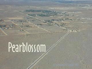
Pearblossom is located about 15 miles (24 km) southeast of Palmdale in the Antelope Valley portion of Southern California.
About Pearblossom
The name Pearblossom came from the multitude of local pear farms along the southern ridge of the Antelope Valley. A few still exist today, but most of those farms are now abandoned and have returned to the desert landscape or have been overridden by small-scale housing development.
Pearblossom is also a popular destination, for its annual Duck Races; convenient location for hiking in the foothills; and picturesque photo opportunities.
Pearblossom is well known by Southlanders as the home of one of the most dangerous roads in the US. State Route 138 (Pearblossom Highway) is the main street in Pearblossom and as of 2004 has been the location of numerous serious and fatal automobile accidents in its Palmdale to I-15 segment. It is known locally as Deathtrap Highway and "The Widowmaker." The road is only single lane each direction for most of this segment's length, and the volumes of traffic that use it are far beyond what it was engineered to handle. The chief reason for accidents according to CHP data is passing the double yellow line in unsafe conditions. Overuse of Pearblossom Highway is chiefly on Friday evenings, Saturdays and Sundays, the time period many use the route to travel to Las Vegas. This section of 138's route is commonly used as a bypass of the Los Angeles Metropolitan region, and as a route from the Antelope Valley to the Inland Empire. Highway 138 or Pearblossom Highway has been somewhat improved, now with three or four lanes along some segments, and some of the dips taken out of the highway in many of the most dangerous areas.
Pearblossom in the arts
Pearblossom (in name only at present) is found in the following creative works:
Pearblossom Highway (1986) was actually photographed in the Littlerock rural vicinity; it, like Huxley's The Crows of Pearblossom, is not about Pearblossom proper.
In 1997, Western actor Louis R. Faust died in his Pearblossom lodgings on Hwy 138. His son, Louis R. Faust, Jr., expired here in 2010.