
Country Russia Area 39 km² | Town of district significance Pavlovo Local time Saturday 6:52 AM | |
 | ||
Municipal district Pavlovsky Municipal District Weather -1°C, Wind NW at 11 km/h, 92% Humidity | ||
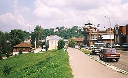
Pavlovo (Russian: Па́влово), or Pavlovo-na-Oke (Russian: Па́влово-на-Оке́), is a town and the administrative center of Pavlovsky District in Nizhny Novgorod Oblast, Russia, located on the right bank of Oka River in the northwestern part of the Volga Upland. Population: 60,698 (2010 Census); 64,814 (2002 Census); 71,543 (1989 Census).
Contents
- Map of Pavlovo Nizhny Novgorod Oblast Russia
- Administrative and municipal status
- History
- Economy
- Agriculture
- References
Map of Pavlovo, Nizhny Novgorod Oblast, Russia
Administrative and municipal status
Within the framework of administrative divisions, Pavlovo serves as the administrative center of Pavlovsky District. As an administrative division, it is incorporated within Pavlovsky District as the town of district significance of Pavlovo. As a municipal division, the town of district significance of Pavlovo is incorporated within Pavlovsky Municipal District as Pavlovo Urban Settlement.
History
Pavlovo was first mentioned in a letter by Ivan the Terrible dated April 15, 1566 which is considered to be the founding year of the town.
Economy
Pavlovo has a long tradition of metalworking industries. One of the main enterprises in the city is Pavlovo Bus Plant (PAZ).
Agriculture
Lemon trees suitable for indoor cultivation were developed in Pavlovo in the 19th century and are grown throughout Russia.