
Type Crater lake Surface area 1,531 acres (619.6 ha) Area 6.2 km² Catchment area 44.29 km² | Primary inflows Surface elevation 1,930 m Mean depth 50 m Shore length 10.8 km | |
 | ||
Location | ||
Paulina lake oregon time lapse hd1080p
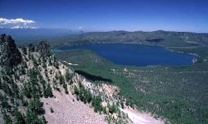
Paulina Lake is one of the twin crater lakes in Newberry Crater, central Oregon, United States (the other being East Lake). It is located 6,331 feet (1,930 m) above sea level in the Deschutes National Forest near La Pine. The lake's primary inflow is seepage from East Lake, snow melt, and hot springs, and its outflow is Paulina Creek, a tributary of the Deschutes River. It has an area of 1,531 acres (619.6 ha), a volume of 249,850 acre feet (308,185 dam3), a maximum depth of 250 feet (76.2 m), a shore length of about 6.7 miles (11 km), and a residence time of about 46 years. The lake is classified as mesotrophic, with a transparency of approximately 13.1 feet (3.99 m). It is about 40 feet (12 m) lower and one mile west of its twin, East Lake.
Contents
- Paulina lake oregon time lapse hd1080p
- Map of Paulina Lake Oregon 97739 USA
- Paulina lake loop hike oregon
- References
Map of Paulina Lake, Oregon 97739, USA
Paulina Lake sits within the Newberry Crater, formed from over 500,000 years of volcanic activity. Once devoid of fish, the lake is now regularly stocked by the Oregon Department of Fish and Wildlife, and is known for its large number of kokanee salmon and brown trout. Other fish found in the lake include rainbow trout, tui chub, and blue chub.
The lake bears the name of Paulina, a Snake Indian.