
Population 2,059 (2011 census) Civil parish Patrington Local time Friday 5:20 PM | OS grid reference TA314226 Dialling code 01964 | |
 | ||
Weather 8°C, Wind NE at 18 km/h, 75% Humidity | ||
Patrington is a village and civil parish in the East Riding of Yorkshire, England, in an area known as Holderness. It is situated approximately 9 miles (14 km) south-east of Hedon and 4 miles (6.4 km) south-west of Withernsea on the A1033 road. It is associated along with Winestead, as a seat of the ancient Hildyard/Hilliard/Hildegardis family.
Contents
Map of Patrington, Hull, UK
The Prime Meridian passes just to the east of Patrington.
The civil parish is formed by the villages of Patrington and Winestead and the hamlet of Patrington Haven. According to the 2011 UK census, Patrington parish had a population of 2,059, an increase on the 2001 UK census figure of 1,949.
RAF Patrington, built during the Second World War, was a radar station and used for ground-controlled interception. In 1955, following the building of a new RAF station at nearby Holmpton, the radar site closed, being surplus to requirements. The new radar site at Holmpton was later renamed RAF Patrington.
Patrington was served from 1854 to 1964 by Patrington railway station on the Hull and Holderness Railway.
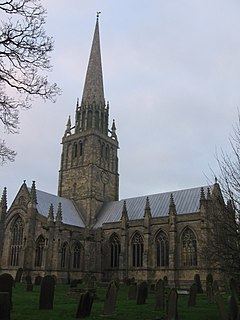
The parish church of St Patrick is an outstanding example of the decorated period of Gothic architecture. It is known as the "Queen of Holderness" and is a Grade I listed building. It contains an Easter Sepulchre.