
 | ||
The Description Of The Grant
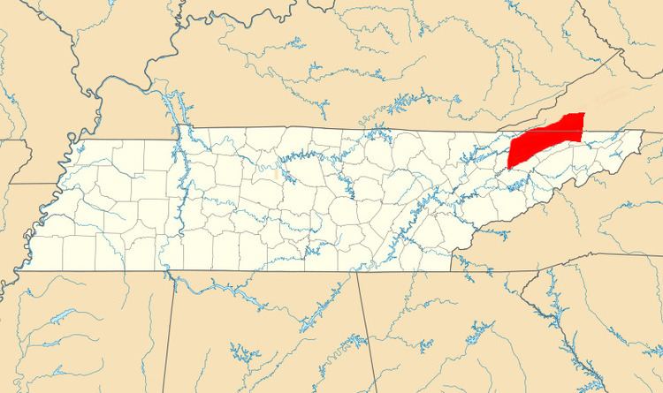
To grasp the scope of the Path Grant, it can be considered as a five sided irregular polygon lying along the valleys of the Clinch and Holston Rivers.
Contents
- The Description Of The Grant
- The Reason For The Path Grant
- Events at the Watauga Treaty Gathering
- The Deed Map
- The Consideration For The Grant
- The Opposition of Dragging Canoe
- Names of Signatory Chiefs
- References
The long southerly boundary is the Holston River. The long northerly boundary is Powell’s Mountain ridge line that lies adjacent to a section of the Great Grant boundary and the Powell’s River valley leading to Cumberland Gap. That is to say, a portion of the Path Grant long Powell's mountain boundary is contiguous with the Great Grant boundary. The Wilderness Road envisioned by Daniel Boone began at the Holston River settlements at the present day Kingsport Tennessee, traversed up into Virginia through the Moccasin Gap of Clinch Mountain and thence across Powell’s Mountain to the Powell’s River valley. The Path Grant provided ownership transfer of the contested Holston River settlements and the Cherokee lands that must be crossed to reach the Powell’s River valley and the Great Grant lands.
When the description of the Path Grant is considered it seems somewhat vague except for one point specifically described. That point is on the Holston River six miles east of the Long Island, where Holston River crosses the Virginia line.
The Treaty of Lochaber in 1771 established the point in question and was made as part of the Donaldson survey establishing a revised western border for the Virginia Colony. A survey was made by Col. Donaldson including Cherokee members of the survey party, that established the survey line from the point on the North Carolina/ Virginia border to a point at Point Pleasant, West Virginia where the Kanawha river meets the Ohio river. That is the same set of points and the line noted in the Path deed recital.
The point six miles from the Long Island is thus not dependent on how to measure six miles on a meandering river but is fixed by the river and the Latitude 36° 30’. Today that point is fixed as 36° 30‘ north latitude 82° 29’ west longitude. The point is the center of the Holston River that is now Fort Patrick Henry Lake within the boundary of Warriors Path State Park. There is no structure or other man made feature marking the point. The present day Virginia/Tennessee line is north of this point and no longer 36° 30’ north latitude.
Additionally, the Lochaber Treaty point is not to be confused with a second intersection of the Holston river and the parallel of latitude 36° 30’ further down stream and also noted in the Path Grant.
It is considered not possible to determine the polygon’s short southwestern boundary line with certainty. A precise description was finessed by the negotiators with 14 words. “beginning on the Holston River where the courses of Powell Mountain crosses the same”
The line is said to follow the course of Powell’s mountain to the Holston river. The course of Powells mountain however does not intersect the Holston river.
When considered with the boundary of the Great Grant, the south western boundary becomes apparent.
The Path Grant short southwestern boundary is an extension of the Great Grant line extending from the southern end of Powell’s Mountain to a point just west of Cumberland Gap. That point is the current intersection of the borders of Virginia, Kentucky and Tennessee. The complete line for both grants thus extends from the intersection of the three counties on the Holston River as noted above northward to the point of intersection of three states on Cumberland Mountain just west of the Cumberland Gap..
A major route, referred to often as the Great War Path, traverses northeasterly through the Holston River Valley. At Bean Station, Tennessee junction, a trail extends northward across Clinch Mountain at Bean’s Gap and onward to the Cumberland Gap. It includes the important way point and junction Bean’s Station. That route is an alternate Path into the Cumberland Gap and Great Grant lands.
Similarly, the short Northern polygon boundary is not described with certainty. The line northward is on the Lochaber treaty line to the top ridge of Powell’s Mountain. The top ridge is presumed to be the ridge line of High Knob that curves eastward over to the Lochaber Treaty line and the north east grant corner.
Although some of the description is somewhat vague, some is quite specific. The course of Holston river as it meanders is the polygon’s long southern line until it strikes the extension of the Lochaber Treaty survey line. The line then follows that 36° 30’ Donaldson's survey line to the point 6 miles from Long Island (Tennessee). By ceasing to follow the Holston river to the treaty line point some land south of the river was included in the Path Grant. Until March 1775 deed date, land south of the Holston river in the vicinity was unsettled and was Cherokee. The most immediate land that comes to view on the map today is The Long Island of The Holston River. The Long Island was important, even sacred to the Cherokee. This very specific line included in a deed with other very long and nonspecific lines makes it a very important departure from the geographically defined borders. The Cherokee sold the Long Island as a part of the Path Grant. If that is the reason, then Dragging Canoe’s opposition justification takes on merit.
The long northern boundary of the polygon is the ridge line of Powell’s Mountain from its beginning on the south end to the high point at High Knob.
The Reason For The Path Grant
The purpose of the 9 man syndicate that was Henderson and Co was to purchase the lands of the Great Grant known as the Transylvania Colony from the Cherokee. Those lands are located within what is now Kentucky and Middle Tennessee. The syndicate needed a way, a route, a path into those Transylvania Colony lands. At that time, in 1775, the western border of Virginia extended down the Holston River Valley to the noted point on the south fork of the Holston River that was 6 miles up stream from the Long Island. At that point the land to the west was owned by the Cherokee.
The route down the Holston River valley was easily traversed. There were actually settlers, perhaps illegal settlers, living adjacent or nearby to the Long Island. What was needed was a route from this location to the Transylvania lands. That route was across Cherokee lands and subject to all sorts of possible problems with the Cherokee. There was a need to secure that route and the method was to purchase those lands in addition to the Great Grant Transylvania Colony lands.
The syndicate hired Daniel Boone to survey and develop the route. The route is known presently as the Wilderness Road. That path began at what is now Kingsport Tennessee, north across the North Fork of the Holston into present day Virginia, through the Moccasin Gap of Clinch Mountain, across the Clinch River and thence to Powell’s mountain where the Transylvania colony lands began. The result was the Path Grant that secured not only the route to Transylvania colony lands but the Holston River settlements and other settlements on the Clinch River.
Events at the Watauga Treaty Gathering
The parties, 1,200 Cherokee and more than 600 whites, gathered at Sycamore Shoals in March 1775 to negotiate the sale of much of the land that is now Kentucky and which is the subject of the Great Grant Deed. It was necessary to hold a second negotiation for land from the Holston River settlements to the Powell Valley to permit unmolested access to the Great Grant lands. That negotiation resulted in the Path Grant. On March 19, 1775, after the negotiations with the Henderson Co, the lease holders for the Watauga settlements around Sycamore Shoals purchased forever from the Cherokee Nation their leaseholds and Jacob Brown purchased his leasehold for the Nolichucky settlements. John Carter and Robert Lucas purchased the recently acquired Carter’s Valley from the Richard Henderson Co. Others say the Carter property was awarded as payment for damages resulting from the Cherokee attack and burning of his Carter’s valley store The result of this series of transactions transferred most of upper east Tennessee from Cherokee ownership to the settlers.
A very good and detailed account of all events pertaining to the gathering at the Fort Watauga and the various grants may be found at web books The Conquest of the Old Southwest.
The Deed Map
The line of 36° 30’ north latitude was established as the Virginia/Carolina border by the king of England in the Carolina Charter of 1655. Generally, the Path Grant boundaries include the land laying between Powell’s Mountain on the north and the Holston river on the south. The land includes the Clinch River valley and the Holston River Valley. The various corner points and lines can be easily located on Google Earth.
The Consideration For The Grant
Prior to the gathering and negotiations, “chief Atta kulla-kulla, a young Buck and a squaw” journeyed to North Carolina to view the goods. Their report was favorable and perhaps exaggerated the wealth to be gained from the sale. The payment in valuation of 10,000 British Pounds was made in both silver and goods. The description of goods for the Path Grant is said to consist of “two thousand weight of leather in goods".
The potential acquisition of such abundance of unavailable goods proved to be adequate motivation for the chiefs and their people to overcome the opposition of those opposed to the sale of their lands. There is thus some ambiguity between the language of Great Grant and Path Grant deeds and the historical record. The consideration in both the Great Grant and the Path Grant deeds is said to be 10,000 British pounds. The consideration for the Path Grant is said to be two thousand weight of leather in goods. It can be deduced that there was one payment for both grants totaling 10,000 pounds in money and goods and a separate sweetening of two thousand weight of leather. The research does not yield an unambiguous certainty for the total.
The Opposition of Dragging Canoe
When Dragging Canoe made his speech, it can be argued he was not especially opposed to the sale of the lands around what is now Frankfort or Louisville or even Nashville. Dragging Canoe was opposed to selling the lands along the Holston and Watauga and Nolichucky rivers of East Tennessee. He was opposed to the sale of the Long Island of the Holston. He was opposed to the sale of the lands that were the East Tennessee settlements.
The basis for that argument is his subsequent action. Dragging Canoe did not lead a military campaign to settlements in Kentucky, he led his forces to the Island Flats of the Holston. Old Abram led a second force to attack the nearby Watauga settlement. One wonders if had they not split their force in a two pronged attack if history would have taken a different course. Had their combined forces prevailed in two engagements, there would have been no force to defeat Patrick Ferguson at Kings Mountain and change the course of the Revolution.
On the day of the signing, Dragging Canoe pointed to the west and said ” A dark cloud hangs over that land known as the bloody grounds” Dragging Canoe did not accept the Path Grant Covenants clause noted above.
Names of Signatory Chiefs
The Cherokee Path Grant Deed Signers.....“Alla Cullocullah, Oconistoto, and Savanooko otherwise Coronok.”
The signer Alla Cullocullah is known in modern times as Attakullakulla, Little Carpenter
The signer Oconistoto is known in modern times as Oconostota. Oconostota and Attakullakulla were cousins and principle chiefs. Oconostota was also Attakullakulla’s father in law,
The signer Savanooko otherwise Coronok is known in modern times as Kalanah Savanukah of Chota, the Raven of Chota. “Some historians believe be was Oconostota's nephew, while others stated he married Oconostota's sister. He served as Oconostota's advisor in the second half of the eighteenth-century.”
Although not a signer, Dragging Canoe, aka Tsi'yu-gunsini, played an important historical role in Path Deed related events. He was the son of Attakullakulla and nephew of Oconostota. He was cousin to Nancy Ward who also played a part in events resulting from the granting of the Path deed.