
OS grid reference TQ087063 Sovereign state United Kingdom Local time Friday 10:42 AM District Arun | Civil parish Patching Area 8.46 km² Dialling code 01903 | |
 | ||
Population 259 (Civil Parish.2011) Weather 11°C, Wind NE at 23 km/h, 76% Humidity | ||
How 2 for u drywall repair patching a large hole in your wall
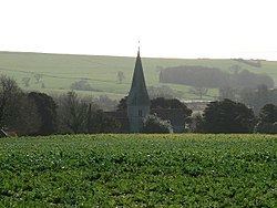
Patching is a small village and civil parish that lies amid the fields and woods of the southern slopes of the South Downs in the National Park in the Arun District of West Sussex, England. It has a visible hill-workings history going back to before the Domesday survey of 1086-7. It is centred four miles (6.4 km) to the east of Arundel, to the north of the A27 road. The civil parish covers an area of 846.12 hectares (2,090.8 acres).
Contents
- How 2 for u drywall repair patching a large hole in your wall
- Map of Patching UK
- Knitting help patching your knits
- References
Map of Patching, UK
In the centre of the village is the 13th century Church of St John the Divine, restored in 1888. Above the village on the South Downs are groups of neolithic flint mines, represented by slight hollows and mounds.
Michelgrove Park, once the site of a great house where Sir William Shelley entertained Henry VIII and later home of the Shelley Baronets, is in the north of the parish. It is crossed by the Monarch's Way long-distance footpath marking the supposed route of Charles II's flight to France in 1651.