
Country United States FIPS code 06-55842 Elevation 80 m Zip code 93630 Area code 559 | Time zone Pacific (PST) (UTC-8) GNIS feature ID 1867049 Area 181 ha Population 2,268 (2010) | |
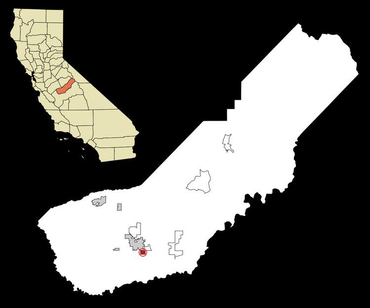 | ||
Parkwood is a census-designated place (CDP) in Madera County, California, United States. It is part of the Madera–Chowchilla Metropolitan Statistical Area. The population was 2,268 at the 2010 census, up from 2,119 at the 2000 census.
Contents
Map of Parkwood, CA 93637, USA
Geography
Parkwood is located at 36°55′37″N 120°02′41″W.
According to the United States Census Bureau, the CDP has a total area of 0.7 square miles (1.8 km2), all of it land.
2010
The 2010 United States Census reported that Parkwood had a population of 2,268. The population density was 3,251.2 people per square mile (1,255.3/km²). The racial makeup of Parkwood was 1,138 (50.2%) White, 123 (5.4%) African American, 48 (2.1%) Native American, 22 (1.0%) Asian, 0 (0.0%) Pacific Islander, 814 (35.9%) from other races, and 123 (5.4%) from two or more races. Hispanic or Latino of any race were 1,784 persons (78.7%).
The Census reported that 2,259 people (99.6% of the population) lived in households, 9 (0.4%) lived in non-institutionalized group quarters, and 0 (0%) were institutionalized.
There were 564 households, out of which 317 (56.2%) had children under the age of 18 living in them, 295 (52.3%) were opposite-sex married couples living together, 130 (23.0%) had a female householder with no husband present, 53 (9.4%) had a male householder with no wife present. There were 58 (10.3%) unmarried opposite-sex partnerships, and 5 (0.9%) same-sex married couples or partnerships. 61 households (10.8%) were made up of individuals and 28 (5.0%) had someone living alone who was 65 years of age or older. The average household size was 4.01. There were 478 families (84.8% of all households); the average family size was 4.24.
The population was spread out with 793 people (35.0%) under the age of 18, 277 people (12.2%) aged 18 to 24, 592 people (26.1%) aged 25 to 44, 438 people (19.3%) aged 45 to 64, and 168 people (7.4%) who were 65 years of age or older. The median age was 26.9 years. For every 100 females there were 102.3 males. For every 100 females age 18 and over, there were 96.9 males.
There were 601 housing units at an average density of 861.5 per square mile (332.6/km²), of which 316 (56.0%) were owner-occupied, and 248 (44.0%) were occupied by renters. The homeowner vacancy rate was 1.6%; the rental vacancy rate was 7.1%. 1,175 people (51.8% of the population) lived in owner-occupied housing units and 1,084 people (47.8%) lived in rental housing units.
2000
As of the census of 2000, there were 2,119 people, 559 households, and 465 families residing in the CDP. The population density was 1,980.2 people per square mile (764.6/km²). There were 580 housing units at an average density of 542.0 per square mile (209.3/km²). The racial makeup of the CDP was 44.64% White, 5.33% African American, 1.98% Native American, 0.76% Asian, 0.05% Pacific Islander, 42.85% from other races, and 4.39% from two or more races. Hispanic or Latino of any race were 65.22% of the population.
There were 559 households out of which 49.2% had children under the age of 18 living with them, 57.1% were married couples living together, 17.5% had a female householder with no husband present, and 16.8% were non-families. 13.1% of all households were made up of individuals and 5.0% had someone living alone who was 65 years of age or older. The average household size was 3.75 and the average family size was 4.09.
In the CDP, the population was spread out with 37.1% under the age of 18, 11.6% from 18 to 24, 28.8% from 25 to 44, 15.9% from 45 to 64, and 6.6% who were 65 years of age or older. The median age was 26 years. For every 100 females there were 101.2 males. For every 100 females age 18 and over, there were 97.2 males.
The median income for a household in the CDP was $34,018, and the median income for a family was $33,411. Males had a median income of $27,656 versus $24,167 for females. The per capita income for the CDP was $9,997. About 19.0% of families and 22.3% of the population were below the poverty line, including 27.8% of those under age 18 and 7.8% of those age 65 or over.
Government
In the California State Legislature, Parkwood is in the 12th Senate District, represented by Republican Anthony Cannella, and the 5th Assembly District, represented by Republican Frank Bigelow.
In the United States House of Representatives, Parkwood is in California's 16th congressional district, represented by Democrat Jim Costa.
Infrastructure
In 2014 during the drought, Parkwood was one of 28 small California communities that cycled onto and off of a list of "critical water systems" that the State Water Resources Control Board determined could run dry within 60 days.