
Legislature House of Commons District created 1976 Last contested 2015 Province Ontario Elector 76,952 | MP Arif Virani
Liberal First contested 1979 District webpage profile, map Census division Toronto | |
 | ||
Peggy nash for parkdale high park
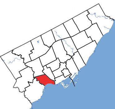
Parkdale—High Park is a federal electoral district in Ontario, Canada, that has been represented in the Canadian House of Commons since 1979. It was created during the 1976 electoral boundaries redistribution from parts of Parkdale, High Park—Humber Valley, Davenport and Spadina districts. Provincially the electoral district is held by Member of Provincial Parliament (MPP) Cheri DiNovo, and municipally by city councillors Sarah Doucette (Ward 13) and Gord Perks (Ward 14). As of the October 19, 2015, Canadian general election, the current Member of Parliament (MP) is Liberal member Arif Virani.
Contents
Geography
It is located in the central-west part of Toronto on the lakefront. It has 106,559 residents. It is composed of the seven neighbourhoods surrounding High Park. Including the park and portions west, between the north and south borders of the park is the neighbourhood of Swansea; north of the park are the neighbourhoods of High Park North and the south half of The Junction; north-west of the park are the neighbourhoods of Runnymede-Bloor West Village and Lambton Baby Point; to the east of the park is Roncesvalles; and Parkdale directly to the south and to the south-east.
It consists of the part of the City of Toronto bounded on the south by Lake Ontario, on the west by the Humber River, and on the north and east by a line drawn from the Humber River east along the Canadian Pacific Railway, southeast along the Canadian National/Canadian Pacific Railway, west along Queen Street West, south along Dufferin Street, west along Dufferin Street, and south along the southerly production of Spencer Avenue.
History
The riding was created in 1976 from parts of Parkdale, High Park—Humber Valley, Davenport and Spadina ridings.
In 1976, it was defined to consist of the part of the City of Toronto bounded on the south by the shore of Lake Ontario, on the north and west by the city limits, on the east by a line drawn from north to south along Runnymede Road, east along Annette Street, south along Keele Street, east along Humberside Avenue, southeast along the Canadian National Railway, south along Bathurst Street; thence southerly along Bathurst Street to the Western Channel of Toronto Harbour.
In 1987, it was defined to consist of the parts of the cities of Toronto and York bounded on the west by the city limits of Toronto and York, and on the north, east and south by a line drawn east along the Canadian Pacific Railway line, south along Runnymede Road, east along Annette Street, southeast along Dundas Street West, east along Dupont Street, southwest along the Canadian National Railway line immediately east of Dundas Street West, south along Atlantic Avenue, west along the Gardiner Expressway, south along the southerly production of Spencer Avenue.
In 1996, it was defined to consist of the parts of the cities of Toronto and York bounded on the west by the city limits of Toronto and York, and on the north, east and south by a line drawn east along the Canadian Pacific Railway, southeast along the Canadian National Railway, south along Atlantic Avenue, west along the Gardiner Expressway, and south along the southerly production of Spencer Avenue.
In 2003, it was given its current boundaries as described above. This riding was unchanged after the 2012 electoral redistribution.
Members of Parliament
This riding has elected the following Members of Parliament:
Toronto Council Wards 13 and 14
Parkdale - High Park is also the name for two wards on Toronto City Council each represented by a city councillor:
The combined ward boundaries roughly corresponds to the federal electoral district.