
Demonym(s) Panicalesi Area 78.8 km² Dialling code 075 | Elevation 441 m (1,447 ft) Time zone CET (UTC+1) Local time Wednesday 3:08 AM | |
 | ||
Frazioni Tavernelle, Colle San Paolo, Missiano, Casalini, Colle Calzolaro, Macereto, Mongiovino, Montale, Colgiordano, Gioveto, Migliaiolo Weather 10°C, Wind W at 3 km/h, 85% Humidity | ||
Italy panicale umbria hd video
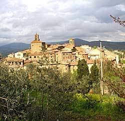
Panicale is a comune (municipality) in the Province of Perugia in the Italian region Umbria. Located on the eastern slope of Mount Petrarvella, in the southeast of Valdichiana, it overlooks Lake Trasimeno and it is about 35 km far from Perugia.
Contents
- Italy panicale umbria hd video
- Map of 06064 Panicale Province of Perugia Italy
- Ducati superbike 1199 panicale autos motorrad ctl4world
- Main sights
- References
Map of 06064 Panicale Province of Perugia, Italy
As of 31 December 2012, it had a population of 5,669 and an area of 78.8 km².
The municipality of Panicale contains the frazioni (subdivisions, mainly villages and hamlets) Tavernelle, Colle San Paolo, Missiano, Casalini, Colle Calzolaro, Macereto, Mongiovino, Montale, Colgiordano, Gioveto and Migliaiolo.
Panicale borders the following municipalities: Castiglione del Lago, Magione, Paciano, Perugia and Piegaro.
Ducati superbike 1199 panicale autos motorrad ctl4world
Main sights
References
Panicale Wikipedia(Text) CC BY-SA