
Country Indonesia Population 174,758 (2010) Founded 17 September 1757 | Province Bangka-Belitung Islands | |
 | ||
University Bangka Belitung University | ||
Map of Pangkal Pinang
Pangkalpinang (official writing style) (simplified Chinese: 邦加槟港; traditional Chinese: 邦加檳港; pinyin: Bāng jiā bīn gǎng, or Pîn-kóng (槟港) in Hakka), is the largest city on the Indonesian island of Bangka, and the capital of the province of Kepulauan Bangka Belitung. It is located on Bangka's eastern coast. The city is divided into seven districts and has 42 wards.
Contents
- Map of Pangkal Pinang
- Jalan jalan malam keliling pangkal pinang tempat warung kopi distro di pulau bangka
- Etymology
- Pre colonial rule
- Colonial rule
- Independent Indonesia
- Demographics
- Topography
- Geology
- Hydrology
- Climate
- Administration
- Festivals
- Landmarks
- Cuisine
- Air
- Sea
- Public Transit
- Economics
- Notable people
- Sister cities
- References
Pangkalpinang has an area of 118.41 km2 and a population of 328,167 (2010 census). Its population density is approximately 2,800/km2. Muhammad Irwansyah is the current mayor; he was preceded by Zulkarnain Karim who served for two terms (2003-2013). The Rangkui river divides the city into two parts. The town is centered on Jalan Merdeka as the zero kilometer point of the city.
The populace of Pangkalpinang consists largely of ethnic Malays, as well as Chinese Hakka who came from Guangzhou. There are also some smaller immigrant communities of other ethnicities, such as Batak and Minangkabau.
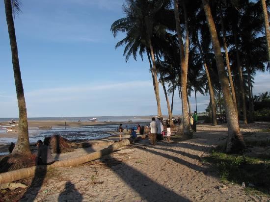
Landmarks in the city include the Timah Museum, a Chinese temple, the Cathedral of St. Joseph, the Bangka Botanical Garden, and the Pasir Padi beach.
Jalan jalan malam keliling pangkal pinang tempat warung kopi distro di pulau bangka
Etymology
Pangkalpinang is derived from the local words pengkal ("base") and pinang (Areca chatecu), a species of palm tree. In Bangka Malay, pengkal means centers or early, or it can be interpreted, in the beginning as a collection center of tin, which later developed as a district center, the town market place, berths or boat (junk) and the center of all activities and events. As the center of all activities, title or Pengkal. The base is also used by the Bangka people in the past to mention areas such as Pangkal Bulo, Pangkal Raya, Pangkal Menduk, Pangkal Mangas, Pangkal Lihat later became known as Sungailiat. Pinang is taken from the local name of the Areca catechu palm, which is widely grown on the island of Bangka.
Pre-colonial rule
Under the rule of Sriwijaya kingdom, Pangkalpinang was populated by Hindus. Aside from being a territory of Sriwijaya, Pangkalpinang was at times also a territory of the Kingdom of Majapahit and the Mataram Kingdom. In the kingdoms of Srivijaya, Majapahit and Mataram, Pangkalpinang received little attention, despite its proximity to international shipping routes. This resulted in Pangkalpinang becoming a hideout for pirates, from where they could prey on ships in the South China Sea
In an effort to secure the shipping routes around the Strait of Malacca, the Johor Sultanate deployed troops to Pangkalpinang. After succeeding initially, the Johor Sultanate began spreading Islam to the city. But this did not last long - the pirates returned to Pangkalpinang and the city was once again a safe haven for them.
Some years later, in another attempt to secure the area from piracy, the Sultan of Banten sent a regent of the archipelago to eradicate the pirates. Once he established control, the Regent of the archipelago ruled Bangka until his death, after which power passed to his only daughter. Because she was married to the Sultan of Palembang, Sultan Abdurrahman, then by itself back into power Pangkalpinang Palembang Sultanate.
Colonial rule
Around the year 1709 tin was dug in the bank of the Olin river in Toboali District by the people of Johor on their experience in the Malay Peninsula. With the discovery of tin, merchants from China and other areas started flocked the city. Tin companies had advanced so much that the Sultan of Palembang sent people to China to seek tin experts for the benefit of the Sultanate. In 1717, the Palembang Sultanate started building trade relationships with the Dutch East India Company (VOC) With the help of the VOC, the Sultan of Palembang attempted to eradicate pirate and tin smuggling .
At the height of the Napoleonic War, the Netherlands was occupied by the France. The British seized all the areas in the Nusantara which is under the Dutch governance. In accordance with the Tuntang Agreement on 18 September 1811 the Dutch handed over the island of Java, Timor, Makassar, Palembang and the following areas of surrender to the British. Pangkalpinang become British colony. Under the British rule, Sir Stamford Raffles sent emissaries to Palembang to take over the Dutch fort in Sungai Aur, but they were rejected by the Sultan Mahmud Badaruddin II because of the Dutch in Palembang has fled/ Raffles was not happy with the rejection and still wanted to take over Fort Sungai Aur. Raffles also demanded that the Sultan gave the tin mines in Pangkalpinang to the British.
On March 20, 1812 Raffles sent the Palembang expedition led by Major General Rollo Gillespie Roobert. But Gillespie failed to meet the Sultan, and the British began to implement political Divide et impera. Gillespie coronate Prince Adipati as the Sultan of Palembang Duke and was given the title Sultan Ahmad Najamuddin II. As a result of the British recognizing Sultan Ahmad Najamuddin II, the Palembang Sultanate handed over the island of Bangka and Belitung to the British. Both islands were now a British colony and were given the name “Duke of Island”.
On the basis of the Anglo-Dutch Treaty of 1824, the Netherlands received back areas once occupied in 1803 from the British, including Pangkalpinang. Fraud, extortion, used of forced labor of the native people by the Netherlands and the British finally ended up making the people lost patience. Moreover, after returning to the Dutch dug a massive tin and did not think about the fate of the people around. Guerrilla warfare was conducted in Musi Rawas against the Netherlands. For many years the people Pangkalpinang make a resistance and fought desperately to expel the Dutch from the city.
At the time of World War II, Bangka was occupied by Japanese troops. Although the period of Japanese rule in Pangkalpinang very short but suffering and misery suffered by the people of Pangkalpinang is extraordinary because of shortages of food and clothing for everyday life.
Independent Indonesia
After Japan surrendered to the Allies and the Indonesian proclamation of independence, Pangkalpinang became part of Indonesia. Pangkalpinang was initially part of South Sumatra province. After the changing of political landscape in Indonesia, Bangka and Belitung Islands was later separated from South Sumatra and was combined as a province with the name of Bangka-Belitung. Pangkalpinang also become part of Bangka Belitung province and acts as its capital city.
Demographics
Pangkalpinang's population was 108,411 in 1990 and has risen to 174,838 at the 2010 Census. The half population is the Malay which mainly speak Bangka Malay ("Bahasa Bangkak"), a variation of Malay dialects that used in Bangka and Belitung region and other half is the Chinese population, who originally immigrated from Guangdong province of southern China. They are called 'Peranakan' ("Children of the Indies") locally, and mainly speak a Hakka dialect with a small minority of Cantonese speakers. In conversation with another Chinese, they call themselves Thong Ngin (Tang People; 唐人) and Fan Ngin (Malay People; 番人) for local Malays.
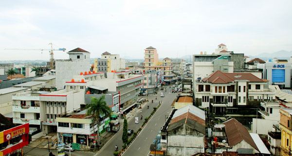
Topography
The topography of the city of Pangkapinang generally undulating and hilly with a height of 20–50 m above sea level and slope of 0-25%. Morphologically concave-shaped region where part of the city center located in the area is low. Hilly areas clustered in the west and south of the city Pangkalpinang. Some of the main hill is Mount Girimaya at an altitude of 50 m above sea level and Tower Hill. While the urban forest area of 290 ha located in the Old Village area Tunu Indah Based Pangkalpinang can be detailed land use; dry land area cultivated for agriculture (food crops, smallholder, fisheries and forestry) is an area of 1,562 hectares, which while not cultivated land area of 1,163 ha and dryland used for settlement covering an area of 4,130 Ha. While the remaining 2,085 hectares are in the form of swamps, forests and other countries.
Geology
Land in the City of Pangkalpinang has an average pH below 5 with red-yellow podzolic soil type, regosol, Gleisol and organosol which is weathering of parent rock. While on a small area of bog soil type Alluvial-Hydromorf associations and Glayhumus and light gray regosol derived from the deposition of sand and clay. Such soil conditions less suitable for rice, but still allows for arable crops. In the suburbs, the Village and the Village Air Itam Tuatunu potential yield of pepper and rubber. Geological conditions prevalent in this area; The oldest formations are limestone aged Permo Carbon, Slate following the Upper Triassic aged and aged granite intrusion last after Trias Jura. The composition of the granitic rocks range from granite to dioditik with dark-colored mineral inclusions are biotite and amphibole occasionally Green.
Hydrology
In the city of Pangkalpinang there are several rivers, in general, small rivers that exist in the region boils down to the Rangkui River. Beside the Rangkui River there are also the Pedindang River in the south. Both of these rivers serve as the main channel rain water disposal city which then flows into the Baturusa River and ends in the South China Sea. These rivers in addition to functioning as the main channel rain water disposal of the city, also functioned as a river transport infrastructure of the market to Baturusa river and on to the sea. Basically region Pangkalpinang judging morphologic concave shape in which the lower part of the town center, so that this situation had a negative impact, which is prone to flooding, especially during the rainy season or the influence of the tide through Rangkui River that divides the city of Pangkalpinang. The area that never stagnant located in the north, west and south of the city. While the Eastern regions bordering Rangkui River and South China Sea and the central part of the city is bordered by a river Rangkui often flooded by the tide (rob), the area flooded, especially the District Rangkui, Pangkal Balam and Taman Sari.
Climate
Climate Pangkalpinang City area classified as tropical wet type A with variation between 56.2 and 337.9 mm of rain per month during 2003, with the number of rainy days on average 16 days setaip month. The driest month is August. Eve in this area is influenced by the sea, both the wind and moisture. Temperatures during 2003, for example, varies between 23.3 and 32.4 degrees Celsius, while the humidity ranges between 76-88 percent. The wind moves every day with the direction of the East and of the West during the day at night. The average wind speed is quite varied each month is 3 knots in February and the highest was recorded in July, August and September, which is 5 knots.
Administration
The city is divided into five districts (kecamatan), tabulated below with their 2010 Census population:
Festivals
As part of the range and the soil clump wither, Pangkalpinang have diverse customs and cultures. The ethnic diversity of the various cultures that form the archipelago unique and attractive, as well as traditional art continues to grow rapidly.
Landmarks
Cuisine
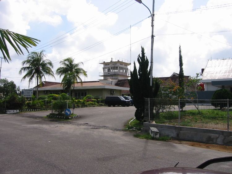
Air
Depati Amir Airport is currently the largest airport in the Bangka-Belitung province. It served daily flights to Jakarta, Palembang, Tanjung Pandan and Batam, operated by different airlines such as Garuda Indonesia, Citilink, Lion Air and Sriwijaya Air. A new terminal started operating on 11 January 2017. The new terminal has a capacity to accommodate 1,500,000 passengers annually and has an area of 12,000 m2.
Sea
Pangkalbalam Port is the main seaport in the city, serving the transportation of goods such as export / import and inter-island trade and passenger transport to and from Jakarta and Tanjungpandan through every day. There are other smaller seaport such as the Muntok port which serves speedboats to and from Palembang. There are other ports in the southern part of the island of Bangka, namely Sadai the airport ferry from Port Cigading, Banten.
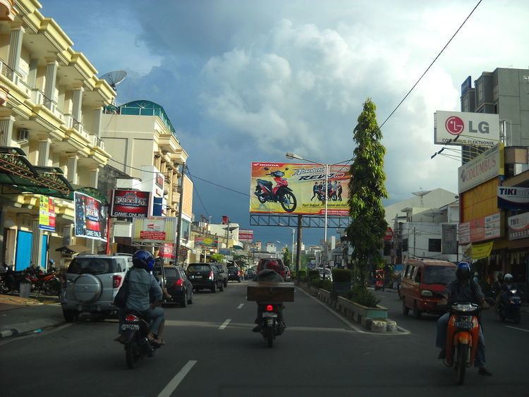
Public Transit
There are currently no public transit in the city. However, there are minibus known as Angkot that serves as a public transport within the city. Angkot also serves as a transportation to other districts outside the city limit.
Economics
In general, agricultural enterprises do Pangkalpinang City community is agricultural food crops, livestock, fisheries and little effort smallholder plantations (rubber, pepper and coconut). In the fisheries sector, as part of the area of Bangka island surrounded by the sea, the city of Pangkalpinang bordering the South China Sea, then made one of the central areas of marine fish production. In addition there is still a small portion of fishermen who undertake fishing in the river. While in the tourism sector, Pangkalpinang has the potential to be reliable. A visit to the district of Bangka and Belitung generally through or transit of this area. Travel Attraction that stands out is the beach, which has stunning scenery.
Notable people
Antasari Azhar, mantan ketua KPK