
Parent range Kumaon Himalaya Prominence 1,614 m | Elevation 6,904 m Listing Ultra-prominent peak | |
 | ||
Location Pithoragarh, Uttarakhand, India First ascent 1973 by an Indo-Tibetan Border Police expedition, led by Mahendra Singh – Panchchuli-2 (6,904 m) Mountain range Himalayas, Kumaon-Himalaya Similar Trisul, Nanda Devi, Nanda Kot, Chaukhamba, Nanda Ghunti | ||
Nandadevi temple panchchuli peaks munsiyari kumaon uttarakhand
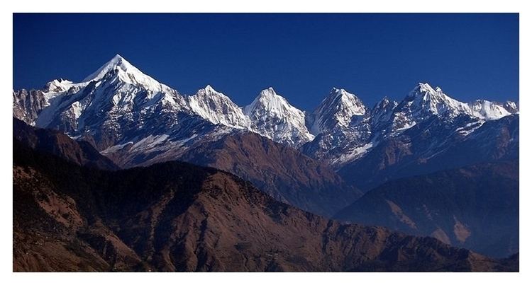
The Panchachuli (पंचाचुली) peaks are a group of five snow-capped Himalayan peaks lying at the end of the eastern Kumaon region, near Munsiari, in Pithoragarh district, Uttarakhand state, India. The peaks have altitudes ranging from 6,334 metres (20,781 ft) to 6,904 metres (22,651 ft). They form the watershed between the Gori and the Darmaganga valleys. Panchchuli is also located on the Gori Ganga-Lassar Yankti divide. The group lies 138 km (86 mi) from Pithoragarh.
Contents
- Nandadevi temple panchchuli peaks munsiyari kumaon uttarakhand
- Map of Panchchuli Uttarakhand 262545
- Panchachuli 1 6355 m
- Panchachuli 2 6904 m
- Panchachuli 3 6312 m
- Panchachuli 4 6334 m
- Panchachuli 5 6437 m
- Approaches to Pancha Chuli
- References
Map of Panchchuli, Uttarakhand 262545
The five peaks on the Panchchuli massif are numbered from northwest to southeast. The highest peak is Panchchuli II, which was first scaled by an Indo-Tibetan Border Police expedition, led by Mahendra Singh, on 26 May 1973. One theory of the group's name is derived from the legendary Pandavas's "Five Chulis" (cooking hearths), where they cooked their last meal before proceeding toward their heavenly abode. Another theory is that this region was once part of the old Nepal Kingdom and in the Nepalese language Chuli refers to peaks, hence the 5 peaks.
Panchachuli-1 (6,355 m)
The first ascent of this peak was done by Indo-Tibet Border Police (ITBP) team in 1972, via Uttari Balati glacier, led by Hukam Singh. The coordinates of this peak are Latitude 30°13'12" Longitude 80° 25'12".
Panchachuli-2 (6,904 m)
This is the highest peak in the group and the highest peak lying entirely in the Kumaon region. It was first climbed successfully by an Indo-Tibetan Border Police team, led by Mahendra Singh, on 26 May 1973. They climbed from the Balati plateau and via the southwest ridge to the summit. The coordinates of the peak are Latitude 30°12'51" Longitude 80°25'39".
Panchachuli-3 (6,312 m)
This peak have been not climbed , there have been a few expeditions and attempts. The first attempt was in 1996 via the Dakshini Balati Glacier on the Munsiari side, this attempt ended after an accident and avalanche. The second attempt was in 1998, by a large Army expedition, lead by Colonel Bhatt of the Engineer Corps of the Indian Army , via the Duktu Glacier on the Dhauli Ganga river side, this too was not successful as the team summiting had an accident on the final approach ridge.
Other reports of a successful climb have not been independently verified.
The coordinates of this peak are Latitude 30°12'00" Longitude 80°26'24".
Panchachuli-4 (6,334 m)
The first ascent of this peak was made in 1995 by a New Zealand expedition led by John Nankervis. The expedition members who summited were; John Nankervis (Wellington), Peter Cammell (Auckland), John Cocks (Dunedin), and Nick Shearer (Oamaru). Peter Platts (Christchurch) assisted the expedition as far as camp 2. The coordinates of this peak are Latitude 30°11'24" Longitude 80°27'00".
Panchachuli-5 (6,437 m)
The first ascent of this peak was made in 1992 by an Indo-British team jointly led by Chris Bonington and Harish Kapadia by the south ridge. Stephen Venables was one of the people in the team who successfully summited, he however had an accident while descending and a daring rescue operation by the Indian Air force helped evacuate him to safety.
The coordinates of this peak are Latitude 30°10'48" Longitude 80°28'12".
Approaches to Pancha-Chuli
- Eastern approach: via the Sona Glacier and Meola Glacier.
- Western approach: through the Uttari Balati Glacier via Balati Plateau.