
Total islands 1 Length 19 km (11.8 mi) Elevation 338 m | Adjacent bodies of water Solomon Sea Major islands Pana Tinani Width 6 km (3.7 mi) Area 78 km² | |
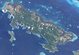 | ||
Pana Tinani is an island in the Louisiade Archipelago in Milne Bay Province, Papua New Guinea.
Contents
Map of Pana Tinani, Papua New Guinea
Geography
The island has an area of 78 km2, making it the sixth largest island of the Louisiade Archipelago. The island is hilly, rising to 338 m at Mt. Guyuba. The island is 3.1 km north of Vanatinai, and separated from it with the Bulami Channel. It is also 100 meters east of Nigao, the easternmost island in the Calvados Chain. separated with the Magamaga Channel.
History
The island was discovered in the late 18th century, named after the wife of the explorer Joannett.
Population
At the census of population in 2014, the island had 740 inhabitants, spread across 11 villages. The main town is Bwailahina (formerly Hebwaun) on the southeast coast. The island's population is administered by 2 wards : Nimoa Ward, Wanim Ward.