
Capital Pampachiri Time zone PET (UTC-5) Area 602.5 km² | Region Apurímac Elevation 3,362 m (11,030 ft) UBIGEO 030210 | |
 | ||
Pampachiri is a rural district in Andahuaylas Province in the Apurímac Region of southern Peru. It is also the name of a village in the district. The population of the district is about 2,400 with about 1,000 of those residents living in the village of the same name.
Contents
Map of Pampachiri, Peru
Before the Spanish conquest it was populated by the Incas, Chancas and Wari peoples who have left numerous archeological sites in the area. There exist populations of pumas, condors and many other rare animals and plants.
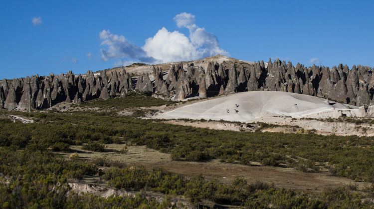
It is an area of outstanding natural beauty. High in the puna area is the spectacular "bosque de piedras" which is an unusual geological phenomena of volcanic rocks in the shape of large smooth cones.
It is situated on the Puquio to Andahuaylas Highway which as of 2010 is still unpaved. The main economic activities of the population are subsistence agriculture and cattle raising (lowlands) and alpaca and vicuña husbandry (highlands). Typical crops grown in Pampachiri include potatoes, corn, alfalfa, and tuna, the fruit of the cactus indigenous to the region. It is one of the poorest districts of Peru with a typical family income of under US$1000 a year.
Ethnic groups
The people in the district are mainly indigenous citizens of Quechua descent. Quechua is the language which the majority of the population (69.69%) learnt to speak in childhood, 29.91% of the residents started speaking using the Spanish language (2007 Peru Census).