
Length 31 km Mouth Amaravati River | Country India | |
 | ||
Main source Talaiyar at
2,073 metres (6,801 ft) River mouth Amaravathi River at
473 metres (1,552 ft) | ||
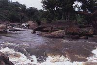
A beautiful view of pambar river in chinnar wildlife sanctuary munnar
The Pambar River originates in the Anaimudi Hills in Idukki District of Kerala state in South India.
Contents
- A beautiful view of pambar river in chinnar wildlife sanctuary munnar
- Map of Pambar River
- Route
- Waterfalls
- References
Map of Pambar River
Route
It traverses Turner’s Valley in Eravikulam National Park and flows into the Chinnar Wildlife Sanctuary through the Taliar Valley between Kanthalloor and Marayoor Villages and eastwards through the sanctuary. The Pambar, Kabani and Bhavani are the only rivers of the 44 in Kerala that flow eastwards. It is joined by seasonal rivulets and a few perennial streams originating from sholas in the upper reaches.
The Pambar merges with the Chinnar River at Koottar where a comfortable tree house accommodation is available. The Chinnar forms the interstate boundary along the northwest edge of the sanctuary and becomes the Amaravati River in Tamil Nadu, reaches the Amaravathi Reservoir and Dam and eventually joins the Kaveri River near Karur.